Ladakh Flash Point

Status
Not open for further replies.

ougoah

Brigadier
Registered Member
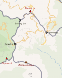
Bhutan officialy claims that the northern part of Doklam is within its territory, even if it is willing to let China have it as part of a diplomatic solution.

And Bhutan has consistently rejected China's request for a land swap involving South Doklam going to China. Both sides care about it the most because of its strategic significance.

Did you read the thread by Tenzing Lamsay?

Okay I get that proving this and showing evidence isn't easy and time consuming so will give you the benefit of the doubt and let's assume the first line is so.

Bhutan was in negotiation talks with China. The deal changes. If Bhutan rejects one offer, China could offer another. The breakdown of bilateral talks on this "swapping" only happened after India interjected and placed military presence in southern doklam where the road connect is required.

To avoid conflict, China simply connected the BRI route in another area. That's all there is to this correct? Do you think otherwise?

Now on the more relevant topic of whether or not China is justified in seeing this as Indian aggression and act against China's interests, it's necessary to know whether such a road connection is a threat to India.

You claimed earlier on that this road overlooks siliguri corridor snad so is a threat to India somehow. Can you explain this line of thinking? These roads a relatively small and designed for trucks and trade. In what capacity does this road have in threatening India's corridor? In today's age of modern warfare and an era where entire road stretches can be made useless by several bombs.
 

twineedle

Junior Member
Registered Member
@ougoah
Please, Log in or Register to view URLs content!

"His Majesty the King explained to the members of National Assembly that there were, basically, four disputed areas between Bhutan and China. Starting from Doklam in the west the border goes along the ridges from Gamochen to Batangla, Sinchela, and down to the Amo Chhu. The disputed area in Doklam covered 89 square kilometers...."
 

ougoah

Brigadier
Registered Member
I'm just trying to explain one reasons for China India relations breaking down despite seemingly decent build towards agreeable relationship.

Doklam drama taking China's point of view was India disrupting China Bhutan bilateral negotiations which were ongoing i.e. Bhutan rejected initial proposals but both could have reached agreeable terms.

From India's point of view, the road is a threat to an Indian corridor. If one looks at a map, it is ridiculous how this 5km stretch into southern Doklam could be any threat to India.
 

ougoah

Brigadier
Registered Member
@ougoah
Please, Log in or Register to view URLs content!

"His Majesty the King explained to the members of National Assembly that there were, basically, four disputed areas between Bhutan and China. Starting from Doklam in the west the border goes along the ridges from Gamochen to Batangla, Sinchela, and down to the Amo Chhu. The disputed area in Doklam covered 89 square kilometers...."

And the existing roads were not in these disputed areas.

The proposed connection runs into disputed area and that's when China talked with Bhutan to do a swap so the connection can be built in China proper.
 

twineedle

Junior Member
Registered Member
And the existing roads were not in these disputed areas.

The proposed connection runs into disputed area and that's when China talked with Bhutan to do a swap so the connection can be built in China proper.
At the time of that report(2002), maybe not. But since then, China had been building roads within those 89 sq km. There wasn't a standoff until 2017, when China tried to extend to Jampheri through the southern part of the plateau. (South of Doka La)
 

Attachments

  • canvas.png
    canvas.png
    227.2 KB · Views: 4

ougoah

Brigadier
Registered Member
1627191021735.png

How does one tiny trade road in the top circled area threaten India's chicken neck in bottom circled? I can understand if it is China negotiating with Bhutan for this land so that it can build a military base and airfield. This is a two lane road for trucks and probably unable to support heavy tanks. In any case, tanks and even untracked military vehicles would not have need to use the road. So the "threat" is always there anyway. A road changes nothing.
 

twineedle

Junior Member
Registered Member
View attachment 75107

How does one tiny trade road in the top circled area threaten India's chicken neck in bottom circled? I can understand if it is China negotiating with Bhutan for this land so that it can build a military base and airfield. This is a two lane road for trucks and probably unable to support heavy tanks. In any case, tanks and even untracked military vehicles would not have need to use the road. So the "threat" is always there anyway. A road changes nothing.
The circled area is not the location of the 2017 standoff, and most of it isn't even in Doklam. The Doklam Plateau is located directly south of Yadong County.
 

ougoah

Brigadier
Registered Member
At the time of that report(2002), maybe not. But since then, China had been building roads within those 89 sq km. There wasn't a dispute until 2017, when China tried to extend to Jampheri through the southern part of the plateau. (South of Doka La)

And that's exactly what I've been saying. Thank you!

China wasn't in any disputed area and when it required a disputed area, China sat down with Bhutan in the hopes of swapping the disputed area China needs for its road connection for whatever Bhutan wants that is agreeable to China. These negotiations were cut by India before China and Bhutan could settle on agreeable swap.

This made China view India as suspect since this road connection doesn't threaten India's chicken neck. Look at any map. It's like a pin in the ocean plus it's a two lane road for trucks. I simply cannot see India's claiming it objected because of this road threatening India.

The real reason is what China suspected, India just wants to be antagonistic to China. Again like I said before if that negotiation was done so that China can get a military base much closer to Chicken Neck, then yeah India has every right to be concerned. China's nearest military base has always been much further and they haven't built any new ones to threaten India's siliguri corridor (chicken neck).
 

twineedle

Junior Member
Registered Member
And that's exactly what I've been saying. Thank you!

China wasn't in any disputed area and when it required a disputed area, China sat down with Bhutan in the hopes of swapping the disputed area China needs for its road connection for whatever Bhutan wants that is agreeable to China. These negotiations were cut by India before China and Bhutan could settle on agreeable swap.

This made China view India as suspect since this road connection doesn't threaten India's chicken neck. Look at any map. It's like a pin in the ocean plus it's a two lane road for trucks. I simply cannot see India's claiming it objected because of this road threatening India.

The real reason is what China suspected, India just wants to be antagonistic to China. Again like I said before if that negotiation was done so that China can get a military base much closer to Chicken Neck, then yeah India has every right to be concerned. China's nearest military base has always been much further and they haven't built any new ones to threaten India's siliguri corridor (chicken neck).
But Prior to 2017, China had built roads within the 89 sq km of disputed areas identified by the King of Bhutan.
 

Attachments

  • canvas.png
    canvas.png
    227.2 KB · Views: 4

ougoah

Brigadier
Registered Member
The circled area is not the location of the 2017 standoff, and most of it isn't even in Doklam. The Doklam Plateau is located directly south of Yadong County.

Yes the disputed area is indeed south of top circled. But top circled shows existing roads that China wanted to connect. That stuff wasn't in disputed land. It was all in China proper which is the top area circled.

The connection that China wanted to initially build in was directly south of this going in a pin drop and far from the chicken's neck. Saying India feels threatened by this is just the official excuse given. The real reason was to create an obstacle for China's BRI.
 
Status
Not open for further replies.
Top