Ladakh Flash Point

Status
Not open for further replies.

Xizor

Captain
Registered Member
The points I have posted are based on my own research.

According to your interpretation of the map, the points are east of Lt. Gen. Panag's interpretation of the LAC, in an area where he says there are no dofferring perceptions. Are you saying he is wrong now?
You did your research?!
Wow. Impressive.

I think you are trying to do your research by occasionally popping up in the thread posting Jai-Hind fantasies. That'd make other members here do the research for you. A person who can't make a map to explain their viewpoint isn't exactly a very motivated researcher.


Do be so kind as to post Lt. Gen. Panag interpretation here. Has he provided a map? Even better. The thread never shies away from new information - whether it be damaging to China or not.


Edit - making these kinds of maps should be so easy for a researcher.
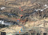
Annotation 2021-03-19 094402.jpg
 

Xizor

Captain
Registered Member
On to a different topic.

Regarding PP15.

As per this Indian article
Please, Log in or Register to view URLs content!


What are PP15 and 17A?

Along the Line of Actual Control (LAC) between India in China, Indian Army has been given certain locations that its troops have to access to patrol the area under its control. These points are known as patrolling points, or PPs, and are decided by the China Study Group (CSG).
CSG was set-up in 1976, when Indira Gandhi was the prime minister, and is the apex decision-making body on China.
Barring certain areas, like Depsang Plains, these patrolling points are on the LAC, and troops access these points to assert their control over the territory. It is an important exercise since the boundary between India and China is not yet officially demarcated.
PP15 and PP17A are two of the 65 patrolling points in Ladakh along the LAC. (Some of these 65 also have an additional Alpha PPs, which are further ahead from the original PPs. So PP17A is different from, but close to, PP17.)

PP15 is located in an area known as the Hot Springs, while PP17A is near an area called the Gogra post.

Where are these two areas?
Both of these are close to the Chang Chenmo river in the Galwan sub-sector of the LAC in eastern Ladakh. While Hot Springs is just north of the Chang Chenmo river, Gogra Post is east of the point where the river takes a hairpin bend coming southeast from Galwan Valley and turning southwest.

I have yet to find an exact location of the mythical PP15. How are the camps of two countries positioned in this region?

Is the "PP15" the same as CK? Is it different?
 

twineedle

Junior Member
Registered Member
You did your research?!
Wow. Impressive.

I think you are trying to do your research by occasionally popping up in the thread posting Jai-Hind fantasies. That'd make other members here do the research for you. A person who can't make a map to explain their viewpoint isn't exactly a very motivated researcher.


Do be so kind as to post Lt. Gen. Panag interpretation here. Has he provided a map? Even better. The thread never shies away from new information - whether it be damaging to China or not.


Edit - making these kinds of maps should be so easy for a researcher.
View attachment 72904
Lt. Gen. Panag made this map back in early June, around the same time as Abhijit Iyer's map. This was him speculating on what possible PLA incursions could be. It is superimposed on the Google imagery, with the yellow line being his own interpretation of India's perception of LAC. Notice how it clearly lines up with the Google lines. He also maintains that there are no differing perceptions at Kongka La.

At that time, he thought PLA had intruded near Hot Springs post, with the purpose of cutting of the road leading from Hot Springs to Kongka La (where those points you mention are. Later, he agreed he was mistaken, and that the conflict points are further north around CK confluence. That's one thing i respect about Lt. Gen. Panag, he admits when he was wrong. Another example was he speculated that China had taken the Galwan heights, but when Nathan Ruser had provided satellite imagery that it was actually India occupying the heights, he took back his earlier claim.
 

Attachments

  • P3.jpg
    P3.jpg
    376.6 KB · Views: 21

twineedle

Junior Member
Registered Member
On to a different topic.

Regarding PP15.

As per this Indian article
Please, Log in or Register to view URLs content!


What are PP15 and 17A?

Along the Line of Actual Control (LAC) between India in China, Indian Army has been given certain locations that its troops have to access to patrol the area under its control. These points are known as patrolling points, or PPs, and are decided by the China Study Group (CSG).
CSG was set-up in 1976, when Indira Gandhi was the prime minister, and is the apex decision-making body on China.
Barring certain areas, like Depsang Plains, these patrolling points are on the LAC, and troops access these points to assert their control over the territory. It is an important exercise since the boundary between India and China is not yet officially demarcated.
PP15 and PP17A are two of the 65 patrolling points in Ladakh along the LAC. (Some of these 65 also have an additional Alpha PPs, which are further ahead from the original PPs. So PP17A is different from, but close to, PP17.)

PP15 is located in an area known as the Hot Springs, while PP17A is near an area called the Gogra post.

Where are these two areas?
Both of these are close to the Chang Chenmo river in the Galwan sub-sector of the LAC in eastern Ladakh. While Hot Springs is just north of the Chang Chenmo river, Gogra Post is east of the point where the river takes a hairpin bend coming southeast from Galwan Valley and turning southwest.

I have yet to find an exact location of the mythical PP15. How are the camps of two countries positioned in this region?

Is the "PP15" the same as CK? Is it different?
No, pp15 is north of CK. 17-17a are CK. There has been some incorrect reporting on those points. The PPs begin near Karakorum pass and extend all the way down to chumar in ascending order. So pp15 would be near Galwan, which has pp14, which is near Depsang, etc.

It looks like that report mixed up pps 15 and 17-17a
 

Xizor

Captain
Registered Member
No, pp15 is north of CK. 17-17a are CK. There has been some incorrect reporting on those points. The PPs begin near Karakorum pass and extend all the way down to chumar in ascending order. So pp15 would be near Galwan, which has pp14, which is near Depsang, etc.
17A isn't CK.

CK can indeed be considered PP17 region.

I do know PP15 lie northwest. But I have yet to see any articles of the situation there or any maps or news of "confrontation".
 

twineedle

Junior Member
Registered Member
17A isn't CK.

CK can indeed be considered PP17 region.

I do know PP15 lie northwest. But I have yet to see any articles of the situation there or any maps or news of "confrontation".
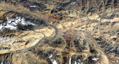
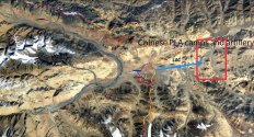
On the point I have marked you can see there are signs of withdrawn PLA camps, as well as large ones just across the LAC> Remember the "recalibrations" article.
 

Xizor

Captain
Registered Member
Lt. Gen. Panag made this map back in early June, around the same time as Abhijit Iyer's map. This was him speculating on what possible PLA incursions could be. It is superimposed on the Google imagery, with the yellow line being his own interpretation of India's perception of LAC. Notice how it clearly lines up with the Google lines. He also maintains that there are no differing perceptions at Kongka La.

At that time, he thought PLA had intruded near Hot Springs post, with the purpose of cutting of the road leading from Hot Springs to Kongka La (where those points you mention are. Later, he agreed he was mistaken, and that the conflict points are further north around CK confluence. That's one thing i respect about Lt. Gen. Panag, he admits when he was wrong. Another example was he speculated that China had taken the Galwan heights, but when Nathan Ruser had provided satellite imagery that it was actually India occupying the heights, he took back his earlier claim.
So in essence, he not only has no better access to information but also provides less detailed map. What do he say about Patrol points? Does he mention them altogether at all?

Let's put all that into perspective P3__01.jpg

PLA camps and even forward patrols are located some 15km away from the LAC. There should be no issue for India here.

However, that's not the case.
Please, Log in or Register to view URLs content!


China remains deployed in significant strength at Gogra, Hot Springs and Kongka La areas, with a large PLA logistics facility supporting troops there.

Elements from a motorised infantry division, an artillery brigade and air-defence unit also remain deployed in the area.

The Chinese Army has outright refused to agree to any pullback of its troops and vehicles in the Gogra and Hot Springs friction points in eastern Ladakh.


April 10, 2021.

The article also mentions Chinese presence in Kongka La areas. I'm ignoring it for the moment anyways. All this mean either the Chinese is further forward than the map convey ( whatever be India's LAC) or the Indian establishment is purposely withholding information.

To be fair, I won't attack the indians for withholding information. China (PLA) doesn't release much information either. But this case - IF it indeed is that of an Indian being on the back foot - doesn't look good for the Indian government.

Why conduct incessant rounds of talks regarding Chinese presence in what is presumably their own region?
 
Last edited:

twineedle

Junior Member
Registered Member
So in essence, he not only has no better access to information but also provides less detailed map. What do he say about Patrol points? Does he mention them altogether at all?

Let's put all that into perspective View attachment 72907

PLA camps and even forward patrols are located some 15km away from the LAC. There should be no issue for India here.

However, that's not the case.
Please, Log in or Register to view URLs content!


China remains deployed in significant strength at Gogra, Hot Springs and Kongka La areas, with a large PLA logistics facility supporting troops there.

Elements from a motorised infantry division, an artillery brigade and air-defence unit also remain deployed in the area.

The Chinese Army has outright refused to agree to any pullback of its troops and vehicles in the Gogra and Hot Springs friction points in eastern Ladakh.


April 10, 2021.

The article also mentions Chinese presence in Kongka La areas. I'm ignoring it for the moment anyways. All this mean either the Chinese is further forward than the map convey ( whatever be India's LAC).

Why conduct incessant rounds of talks regarding Chinese presence in what is presumably their own region?
1. PLA's Kongka La Post is not new, it's been there for a while
2. PLA does have some new forward camps closer to the LAC. You can see all of them on Google Earth, which you hate so much.
4. Status quo ante means both sides completely pull back from the area except for PLA's Kongka LA post and India's Hot Springs Post. Gen. Naravane has been specifically saying India is working towards disengagement, deescalation, and de-induction. Disengagement means both sides pull back forward camps and create distance betwween troops, often using temporary buffer zones. This has been done at most locations with the exception of Gogra(which multiple sources have said is a problem area). deescalation means moving back rear deployments etc. to peacetime locations. Honestly, I don't think that will happen anytime soon.
5, The 1993 agreement specifically was against millitarizing the LAC. You can ask the same question about why China objected to Indian presence and infrastructure construction in Galwan and other areas in the Talks.
6. The article mentions PLA deployments near Kongka La, but no mention of pps greater than 17A


You still have not provided any clear reason why Lt. Gen. Panag is wrong about the LAC, especialy since he is by no means pro gov.
 

Xizor

Captain
Registered Member
1. PLA's Kongka La Post is not new, it's been there for a while
2. PLA does have some new forward camps closer to the LAC. You can see all of them on Google Earth, which you hate so much.
Yes. I do "hate" Google earth. Are we ignoring that almost all my maps have been created in Google Earth?

There are several reasons for not going with Gearth.

1. Google earth can't be used to identify forward deployments or patrols. Camps? Sure.


2. Google earth data isn't accurate. Most of the time, it uses data from years ago. You can see the most recent only from Google earth pro but they arent even upto date.

3. No such existence of Forward deployments in Goggle earth. You may point them out yourself if you feel we have missed forward deployments in Goggle earth.

As far as I know, the stretch of land between Gogra Post and PP19region lie empty.
 
Status
Not open for further replies.
Top