Ladakh Flash Point

Status
Not open for further replies.

Abominable

Major
Registered Member
Not here to discuss the ladakh situation but if am to assume that you're Indian who lives in India, I just want to say to be safe and protect yourself and your loved ones from the scourge of Covid-19 that's currently rampaging in your country writ large. I hope you're not going to take my sincere wish of good intentions in a wrong way.
He's obviously not an Indian who's being affected by the tragedy that is happening in his country as he's got time to troll on a random Chinese internet forum instead of finding a relative an oxygen canister. I notice the fake Indian trolls aren't stopping with their hate campaign on twitter either.

He's probably a high caste brahmin who likes trolling Chinese more than the deaths of his own people.
 

Abominable

Major
Registered Member
Perceived LAC is the official term used by the Indian government. India's official claims are the entirety of Aksai Chin, While China officially does not recognize Ladakh as a part of India. India's perceived LAC for the most part corresponds to where China reached in 1962, but there are some differences in perception by both sides. Once again, this is the official terminology. In areas like Galwan and Hot Springs, China's perception is west of India's, and in areas like Demchok and Pangong, India's is East of the current LAC. I

Where did India have to withdraw? In Galwan and Pangong, India withdrew from forward areas it had never occupied before. In Pangong, India had never held any position east of Finger 4, and Finger 4 effectively blocked off indian troops patrolling on foot. India only forward deployed some temporary camps near finger 4, other than that India is exactly where it was before the standoff started. China meanwhile had created permanent and strategic infrastructure all the way up to its perceived lac but had to dismantle it all and withdraw to shere it started. So status quo ante restored.

In Galwan China's perceived lac is roughly halfway within the Indian controlled portion of the valley, and its claims are even further. During the disengagement, both sides withdrew from the Indian perception of the lac, meaning China is even further back from its lac than it was before Previously India only patrolled the valley when conditions permitted, now it has permanent camps and strategic infrastructure connecting the valley to DBO all the way to the beginning of the buffer zone, which is also China's perception. This is clearly visible on google Earth. In addition, India occupied the heights adjacent to the valley, securing that portion of DBO. So how did India withdraw when in both secotors, China withdrew more? And how did the LAC change? The fact is China tried to shift the LAC westward but failed.

The noly active conflict point of the last standoff is in Hot springs, where China did come pretty close to its perception, which is roughly the confluence of the Kugrang and the Changlung. Previously, Indian patrols never went past pp15 which i roughly located around the confluence, however last summer India forward deployed beyond pp15 into China's perceived lac. During last July's disengagement, China withdrew most of its camps, and now only one Indian and one PLA camp remain in the disputed area, which lies within both the Indian and Chinese perceptions. Once again, the Indian camp is far beyond where Indian soldiers used to patrol. That standoff is still ongoing.

It would be helpful to do basic research on the subject.

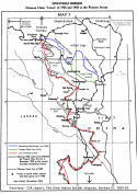
For reference, this is a CIA map of the LAC as it was in the early 2000s. That line stills stands today, despite china's attempts to shift it west, even though both sides still have their perceptions/claims. There is the LAC as it stands(de facto) and the LAC both sides perceive/claim. Neither of those have changed.
No one cares about what the official government terms are other than you.

When the PLA tanks are driving through Delhi this Indian will still be here claiming the perceived LAC is still east of Finger 4.
 

Xizor

Captain
Registered Member
Once again, the LAC at Gogra-hot Springs is clear. Indian perception of the LAC is in Red, Chinese perception in Yellow. The conflict point has always been within the yellow bulge, well beyond pp15

India's historic perception of the LAC at Galwan is also quite clear. Once again, no clear and unbiased evidence has been presented otherwise, just politcally motivated heresay.
Please, Log in or Register to view URLs content!
Once again,

First, this map fails to show the patrol points.
Second, China's perception of Claims.
LAC lies beyond PP. PP15 lies on the other side of the river. Whether the yellow bulge (which signifies China's claim line therefore takes up PP15 is a matter better left to China to decide).


Amusing, you insist it is "politically motivated" but is quite ready to cite a map drawn by a politically motivated think tank shill who smugly and openly admits to its political bias.
 

Abominable

Major
Registered Member
Once again,

First, this map fails to show the patrol points.
Second, China's perception of Claims.
LAC lies beyond PP. PP15 lies on the other side of the river. Whether the yellow bulge (which signifies China's claim line therefore takes up PP15 is a matter better left to China to decide).


Amusing, you insist it is "politically motivated" but is quite ready to cite a map drawn by a politically motivated think tank shill who smugly and openly admits to its political bias.
But it agrees with what his government is saying, therefore it must be right.
 

twineedle

Junior Member
Registered Member
As stated before India's historic perception of the LAC has always been around 500m south of the Galwan bend. This is in line with the CIA map of the early 2000s as well as with historic Indian documents and is exactly what is currently shown on Google Earth, which means the LAC has remained the same as it has been for decades. No clear unbiased evidence has been provided otherwise. It should also be clear that Indian soldiers never patrol exactly to their perception of the LAC, the LAC is typically about 1-3 km from the pps. Even Brig. RJS said Indian soldiers never patrolled past the bend, since any tactical operation there(which includes patrolling) is "suicidal." to quote his words. Last July both sides disengaged from the Indian perception of the LAC, which means China is even further from its perception/claim than it was before.

And no, China never came close to its perception. China's historic claim is roughly 1.5 km from pp`14/bend and about 2 km from the historic Indian claim line, as shown in the below image. As shown in the updated google Earth images, india's furthers forward camp is well past China's historic claim line, while China's furthest camp is even behind the Shukla claim line, let alone India's historic LAC perception. That is not even taking into account the claims implied by the Chinese Embassy, which lie even further west.

1619577213258.png

Even in hot Springs, India is currently deployed well within China's perception.
 

Xizor

Captain
Registered Member
As stated before India's historic perception of the LAC has always been around 500m south of the Galwan bend. This is in line with the CIA map of the early 2000s as well as with historic Indian documents and is exactly what is currently shown on Google Earth, which means the LAC has remained the same as it has been for decades. No clear unbiased evidence has been provided otherwise. It should also be clear that Indian soldiers never patrol exactly to their perception of the LAC, the LAC is typically about 1-3 km from the pps. Even Brig. RJS said Indian soldiers never patrolled past the bend, since any tactical operation there(which includes patrolling) is "suicidal." to quote his words. Last July both sides disengaged from the Indian perception of the LAC, which means China is even further from its perception/claim than it was before.

And no, China never came close to its perception. China's historic claim is roughly 1.5 km from pp`14/bend and about 2 km from the historic Indian claim line, as shown in the below image. As shown in the updated google Earth images, india's furthers forward camp is well past China's historic claim line, while China's furthest camp is even behind the Shukla claim line, let alone India's historic LAC perception. That is not even taking into account the claims implied by the Chinese Embassy, which lie even further west.

View attachment 71428

Even in hot Springs, India is currently deployed well within China's perception.
Bold 1 : False.
Please, Log in or Register to view URLs content!


The map has been discussed before and doesn't depict claims after 1962 war of China.
(it is besides the point that the map is not to scale, zoomed out and is a poor tool for any useful discussion)

You keep posting the same things. I keep answering the usual.

Refer previous posts.
 
  • Like
Reactions: LST

twineedle

Junior Member
Registered Member
The map has been discussed before and doesn't depict claims after 1962 war of China.
(it is besides the point that the map is not to scale, zoomed out and is a poor tool for any useful discussion)
So according to you, what are those claims? multiple maps show China's historic claim roughly 2 km from the current lac. That is not even taking into account China's latest claims, which include the entire valley.
And the ground reality is, China tried to shift the LAC west to match with its historic claims but failed. Tha LAC is the same place it has been for decades.
 
Last edited:

Xizor

Captain
Registered Member
So according to you, what are those claims? multiple maps show China's historic claim roughly 2 km from the current lac. That is not even taking into account China's latest claims, which include the entire valley.
You mean "Perceptions". When you consistently post with the use of the word "Perception" when it comes to Claims and LAC, it's pretty evident you are at discomfort.

China's claim in 1962 seems to have become history (not to its entirety though).
I thought you'd have realized that when China evaded the chance to set down its version of claims for an LAC after the war or recently when she claimed Galwan to most of its entirety.

All we can say is China is dynamic when seeking its claims with regards to India. In many regions it may roughly coincide with the claims in 1960.
 

twineedle

Junior Member
Registered Member
You mean "Perceptions". When you consistently post with the use of the word "Perception" when it comes to Claims and LAC, it's pretty evident you are at discomfort.

China's claim in 1962 seems to have become history (not to its entirety though).
I thought you'd have realized that when China evaded the chance to set down its version of claims for an LAC after the war or recently when she claimed Galwan to most of its entirety.

All we can say is China is dynamic when seeking its claims with regards to India. In many regions it may roughly coincide with the claims in 1960.
I use the word perceptions because that is the official GOI terminology wrt LAC
 
Status
Not open for further replies.
Top