China's SCS Strategy Thread

Please, Log in or Register to view URLs content!


...
it (your 2015 link) appears to be the Fiery Cross flyover mentioned after 01:20 in the vid inside the article Yesterday at 8:06 PM

not sure what's the problem:
the US will keep coming, the Chinese will keep shooing away, the journalists will keep reporting, I guess LOL actually it's pretty entertaining while watched from the middle of Europe
 
Last edited:

Icmer

Junior Member
Registered Member
it (your 2015 link) appears to be the Fiery Cross flyover mentioned after 01:20 in the vid inside the article Yesterday at 8:06 PM

not sure what's the problem:
the US will keep coming, the Chinese will keep shooing away, the journalists will keep reporting, I guess LOL actually it's pretty entertaining while watched from the middle of Europe

The flyover in the latest article was obviously conducted recently and isn't the one from 2015. Note the advanced state of construction on Fiery Cross.

Considering the level of Pentagon approval required, the fact that journalists were invited again means that the timing of this was 100% politically motivated. There is a reason senior US officials want to draw attention to the SCS again.
 
The flyover in the latest article was obviously conducted recently and isn't the one from 2015. Note the advanced state of construction on Fiery Cross.

...
gosh I said
13 minutes ago
"it (your 2015 link) appears to be the Fiery Cross flyover mentioned after 01:20 in the vid inside the article Yesterday at 8:06 PM"
so of course the CNN filmed both flyovers, back in 2015 and now

it's cool stuff, I'm looking forward to see a Type 055 pushing out a Burke in the future, later encounters of whole CVBGs maybe

anyway it's a type of the game which has been played with the Soviets/Russians since 1950s
 

Hendrik_2000

Lieutenant General
From Asia Times
Please, Log in or Register to view URLs content!


Satellites to watch ‘each and every ship’ in South China Sea
Hainan province and the city of Sansha have been tasked with launching and operating a network of satellites which will monitor the entire ocean
By ASIA TIMES STAFF AUGUST 16, 2018 3:39 PM (UTC+8)

China is planning to set up a “CCTV network in space” and will launch satellites to monitor just about all of the South China Sea, with a control room for the network on an island claimed by Vietnam and Taiwan.

In July 2012, Beijing set up a new prefecture-level city made up of a chain of barren atolls and reefs with a minuscule landmass of about 13 square kilometers to exert jurisdiction over 2.6 million square kilometers of open sea.

The creation of the city of Sansha under southern Hainan province was meant to advance Beijing’s claim to almost the entire South China Sea.

Now it appears that 10 new navigation and surveillance satellites will help Sansha’s administration keep a close watch over the vast expanse of sea – and everything that passes through it.

Chinese state media has reported that Hainan would start launching satellites, likely from the Wenchang Spacecraft Launch Site on the province’s east coast, for a “CCTV network in space” to keep watch on the South China Sea.

State media said the satellites would be used for defense and marine rescue purposes and a ground control center would be built on Yongxing Island, also known as Woody Island, that lies in the center of an area of contention between Beijing and its neighbors.

20141208104703940.jpg

An aerial view of Yongxing Island. Photo: Xinhua
“Every reef and ship” would be put under surveillance to deal with emergencies when the system is up and running.

Citing a memo from the Sanya Institute of Remote Sensing under the Chinese Academy of Sciences, the People’s Daily said that work on the first prototype of these earth observation satellites had been underway, with launches scheduled between 2019 and 2021.

These satellites would be able to scan the 3.5-million-square-kilometer South China Sea and update a satellite image database “within days,” compared with the current pace of two to three months for each scan using existing satellites.

The newspaper added that on top of high-resolution cameras, the new satellites would be fitted with an “Automatic Identification System,” although no more details were given.

A researcher with the Institute of Remote Sensing also revealed that the satellites could keep tabs on areas between 20 and 30 degrees north and south from the equator. That means large swathes of the Indian Ocean as well as the Malacca Strait could also come under Beijing’s full glare.

It is believed that since the new satellite network is being proposed by local authorities rather than the Chinese military, Beijing hopes the program will not draw too much ire from other nations that also have claims in the South China Sea.

Hainan and Sansha officials pledged that data about passing ships, reefs and water quality would be shared with other countries.

Please, Log in or Register to view URLs content!


Must-reads from across Asia - directly to your
 

Hendrik_2000

Lieutenant General
very good, LOL will now people listen to
Nov 23, 2016
?

I don't understand what are you trying to say That Zumwalt stealth shape is undetectable?

Not if this new panned to be true In few more years when this constellation of satellite finish Nothing can be hidden See this paragraph combine AIS(Automatic identification ship)

Citing a memo from the Sanya Institute of Remote Sensing under the Chinese Academy of Sciences, the People’s Daily said that work on the first prototype of these earth observation satellites had been underway, with launches scheduled between 2019 and 2021.

These satellites would be able to scan the 3.5-million-square-kilometer South China Sea and update a satellite image database “within days,” compared with the current pace of two to three months for each scan using existing satellites.

The newspaper added that on top of high-resolution cameras, the new satellites would be fitted with an “Automatic Identification System,” although no more details were given.
 
I don't understand what are you trying to say That Zumwalt stealth shape is undetectable?
gosh didn't you get I had said the OPPOSITE?!

did you READ the chunk I reposted:

"... to cut the long story short, I think it's an ILLUSION to try to hide at sea these days (the Bismarck didn't make it to Brest, did she? LOL) and the USN outsmarted itself with the Zumwalts ..."

?!
 
now noticed:
Please, Log in or Register to view URLs content!
Retweeted
Please, Log in or Register to view URLs content!


Looks like there's some tension off the coast of Malaysia, at the South Luconia Shoals. China Coast Guard ship 3401 is operating dangerously close to Indonesia-flagged offshore support ship Java Imperia. Apparently trying to disrupt operations. (file photos)

DkvXLebWwAAarh_.jpg

DkvXLfNXsAAzNzh.jpg

DkvXLf3XsAAn4ca.jpg

DkvXZeIX4AEkJ-y.jpg
 
A rare English language media article that actually describes the "freedom of navigation" international law disagreement between the US and China.

Please, Log in or Register to view URLs content!


The South China Sea: Freedom of Overflight or ‘Unlawful Activities’?
A critique of recent U.S. military reconnaissance activities in South China Sea from the Chinese perspective.

By Yinan Bao
August 16, 2018

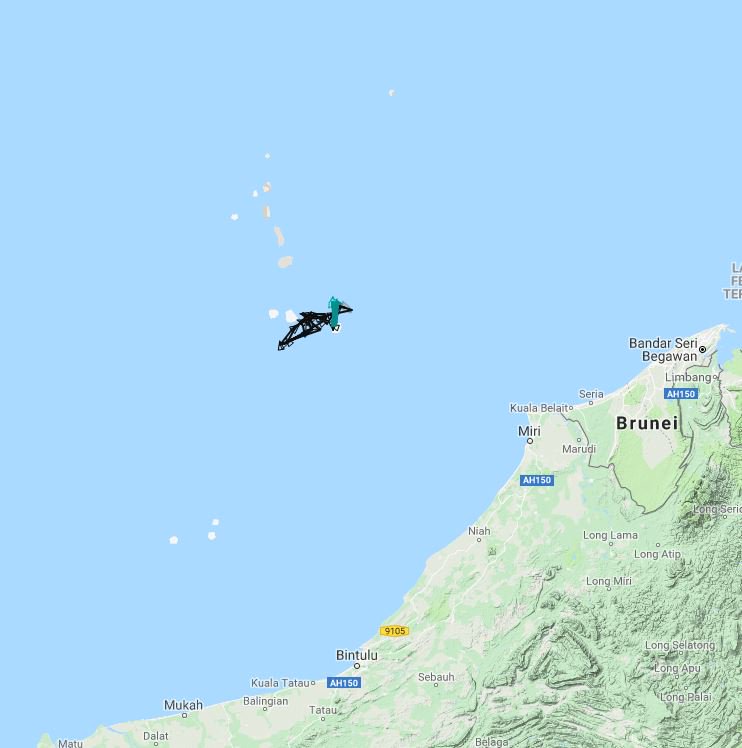
On August 10, CNN reported that a U.S. Navy P-8A Poseidon reconnaissance plane flew over four maritime features in the Spratly Islands in the South China Sea. This incident was actually the third of its kind to take place in a relatively short span of four months this year, following two highly publicized flyover incidents of U.S. B-52 bombers in the Spratly Islands in April and June 2018.

The Nature of the Flyover on August 10

Unlike the two previous flyovers by B-52 bombers, it is not clear whether this time the P-8A flew within 12 nautical miles — the territorial sea — of any of the four features. According to the video recording provided by the CNN, the U.S. pilot replied to his Chinese counterpart that the plane was “conducting lawful military activities beyond the national airspace of any coastal state.” At the first glance, it is thus natural to think that the flyover did take place more than 12 nautical miles from any feature.

However, it is worth mentioning that the U.S. government as well as many eminent U.S. international law scholars, such as Professor James Kraska and Raul Pedrozo, frequently mention the South China Sea Arbitral Award, in which Subi Reef and Mischief Reef were declared by the arbitral tribunal to be “low-tide elevations.” According to Article 13 of the 1982 United Nations Convention on the Law of the Sea (UNCLOS), low-tide elevations generate no territorial sea of their own. Thus, it is possible that the P-8A did fly within 12 nautical miles of these two features. The other two features, namely Fiery Cross Reef and Johnson Reef, were both declared high-tide features by the same tribunal, so they can generate a 12 nautical mile territorial sea.

Even though the Chinese government has yet to specify the territorial sea limits around any feature in the Spratly Islands, it did suggest in its two note verbales to the UN secretary general in 2009 and 2011 that it has sovereignty in “adjacent waters” around features in the South China Sea, a metaphor for the territorial sea. Thus, it is highly unlikely that the P-8A flew within 12 nautical miles of either Fiery Cross Reef or Johnson Reef, if the reply from the U.S. pilot was honest and in good faith. It is worth recalling that in 2015 a U.S. B-52 bomber flew within 2 nautical miles of Cuarteron Reef, another Chinese high-tide feature that possesses a potential territorial sea and above it, territorial airspace. After that incident the United States admitted its mistake and blamed bad weather for the B-52 flying off course.

A more plausible interpretation of the flyover on August 10 is that the P-8A flew in the potential exclusive economic zone (EEZ) around the features of the Spratly Islands. Although the Chinese government has not officially declared any EEZ in the Spratly islands, in the two note verbales mentioned above, it can be suggested that China reserves the right to claim an EEZ based on the provisions of UNCLOS. Notably, the Chinese government also categorically rejected the South China Sea Arbitral Award, in which the tribunal declared that no features in the Spratly Islands can legally generate any EEZ.

Anyway, the U.S. pilot claimed what the U.S. government and scholars always claim: that the reconnaissance plane was exercising rights “guaranteed by international law.” The rights the pilot referred to are the right to carry out military training and the right to carry out military surveillance, all deemed by the United States as included in the “freedom of overflight,” a traditional freedom enjoyed by all states in the high seas, as well as in EEZs, an innovative and sui generis regime established by the UNCLOS.

Chinese and US Divergence in the Interpreting “Freedom of Overflight” in the EEZ

Under Article 58 of UNCLOS, the freedom of overflight enjoyed by all states is expressly stipulated. Meanwhile, the same provision also provides that in exercising their rights, other states “shall have due regard to the rights and duties of the coastal state,” and more important, they “shall comply with the laws and regulations adopted by the coastal state” and other provisions of the UNCLOS and general international law “in so far as they are not incompatible” with the regime of the EEZ. Evidently, it is this lengthy provision that causes much controversy and legal debate between China and the United States.

According to the Chinese interpretation, the exercise of rights in the EEZ is by no means unconditional, but subjected to several “terms and conditions.” First, other states shall exercise their rights in good faith, without any abuse, as required by Article 300 of UNCLOS. Thus, freedom of overflight means that foreign aircraft are granted the right to fly through the EEZ without any unnecessary delay and shall not carry out activities unrelated to the flyover. Accordingly, those flyovers with a definitive military mission will be regarded as an “abuse of rights.”

Second, freedom of overflight can never suggest a right to show off military power and threaten the peace and security of the coastal state. China holds the view that the freedom of overflight can never include activities that may undermine the security interest of the coastal state. Therefore, it is not surprising that a spokesperson of the Chinese Ministry of Foreign Affairs criticized the flyover of two U.S. B-52 bombers in the Spratly Islands in June as a evident threat to the security of China. She likened the move to if “someone armed to teeth comes to your doorstep every now and then, poking around and showing off muscles.” Therefore, such actions provide China with convincing reasons to consolidate defensive installations in its features in the Spratlys.

Third, the exercise of the freedom of overflight shall not violate the domestic laws and regulations of the coastal state. The 2002 Surveying and Mapping Law of the People’s Republic of China requires that surveying by foreign organizations in jurisdictional sea areas of China should receive approval from the Chinese government. Unauthorized surveying may also give rise to criminal responsibility under Article 51 of that law. U.S. military surveillance activities by the reconnaissance plane, if proved to include actual surveying and mapping of various Chinese features, may constitute an overt breach of Chinese domestic law.

By contrast, the United States insists that these military activities are well within the freedom of overflight. That’s what the U.S. pilot replied in the CNN video recording: that he was “operating with due regard for the rights and duties of all states.” Indeed, most U.S. international law scholars endeavor to elaborate that military activities such as surveillance and training are not non-peaceful ipso facto, but instead fall into the category of “other internationally lawful uses of the sea” stipulated in Article 58 of the UNCLOS. Furthermore, U.S. international law scholars also repeatedly advocate that military survey is not maritime scientific research and shall not fall into the jurisdiction of the coastal state in the EEZ.

Here, three legal points call for further comments.
...
Cont'd next post due to character limit
 
Cont'd from previous post due to character limit

...
Analyzing the Nature and Legality of Military Surveillance Activities in the EEZ

First, certain military activities, such as surveillance by aircraft at high altitude, are indeed not directly threatening. Nevertheless, the coastal state may have reasonable doubt about the nature and further implications of such activities. Whether the information collected by foreign military surveillance aircraft will be used against the coastal state in the near future remains a mystery. For instance, if a foreign military surveillance aircraft flies over a key defensive installation in a fortified island in the EEZ of a coastal state three times in a week, it is absolutely reasonable for the coastal state to become wary of the nature and purpose of such activities. It can be asserted that certain kinds of military activities, such as surveillance, may potentially undermine the security of the coastal state, and so, such activities shall not be carried out in the EEZ without any restrictions. Accordingly, it is doubtful that such high frequency surveillance should be considered as a peaceful manifestation of the exercise of the freedom of overflight.

Second, the term “internationally lawful uses” in Article 58 of UNCLOS also requires attention. As a matter of fact, Article 58 provides that “other internationally lawful uses of the sea” should be “related to the freedom of navigation, overflight, and of the laying of submarine cables and pipelines.” The same provision lists some examples, such as activities “associated with the operation of ships, aircraft, and submarine cables and pipelines.” Accordingly, activities that are not related to the freedom of navigation, overflight, or laying of submarine cables and pipelines are not considered as “other international lawful uses of the sea” under Article 58, even if these activities are normally considered as lawful.

For instance, aerial refueling of a military aircraft can be regarded as “internationally lawful” as refueling is a kind of maintenance activity essential for the normal operation of an aircraft. By contrast, military surveillance by a reconnaissance plane is in no way related to the normal operation of aircraft, and surveillance activities bear a distinct mission objective other than normal flight. Hence, it is against the context of Article 58 to consider military surveillance as “internationally lawful use of the sea,” and it should not be considered as exercising the freedom of overflight in the EEZ.

Finally, whether military surveillance by foreign military aircraft in the EEZ of a coastal state should be subjected to the jurisdiction of the coastal state is worth analyzing. Here, the difference between maritime scientific research and military surveying may provide a good answer. It is expressly stipulated in Article 56 that the coastal state enjoys exclusive jurisdiction over maritime scientific research. Eminent U.S. international law scholars such as J. Ashley Roach and James Kraska argue that military surveying shall not be considered as maritime scientific research, owing to the different nature and purpose between these activities.

If so, it will create an ironic paradox: in the EEZ, those benign, purely scientific research activities by foreign civil aircraft are subjected to the authorization of the coastal state, while highly sensitive and even potentially threatening military surveying by foreign military aircraft can be carried out freely without any interference and regulation from the coastal state. This is perhaps one of the most ironic interpretations in the whole UNCLOS, if not the most absurd one.

To sum up, it is reasonable to assert that the recent military surveillance activities by the U.S. reconnaissance plane are by no means lawful under UNCLOS. Therefore, the U.S. military should refrain from executing similar operations in the Spratly Islands in the future.

Dr. Yinan BAO specializes in diplomatic law and the law of the sea. He is currently working as a research associate in the School of International Law, East China University of Political Science and Law, based in Shanghai, China.
 
Top