
You are using an out of date browser. It may not display this or other websites correctly.
You should upgrade or use an alternative browser.
You should upgrade or use an alternative browser.
China's Space Program News Thread
- Thread starter crazyinsane105
- Start date
- Status
- Not open for further replies.
by78
General
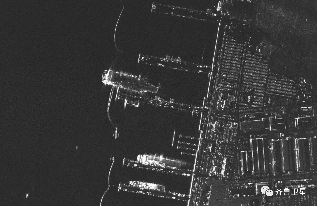
Some images taken by Qilu-1 (齐鲁一号) satellite. Qilu-1 is China's first compact SAR satellite operating in the Ku-band. The first three images are scans of the Norfolk Naval Station in Virginia obtained using sub-meter beamforming. The last two are from a scan of the Suzhou.


escobar
Brigadier
GF-12 (3) successfully launched. A 30cm GSD SAR sat

In certain bands you can see through the roofs of the buildings to see the machinery inside.Some images taken by Qilu-1 (齐鲁一号) satellite. Qilu-1 is China's first compact SAR satellite operating in the Ku-band. The first three images are scans of the Norfolk Naval Station in Virginia obtained using sub-meter beamforming. The last two are from a scan of the Suzhou.
Some images taken by Qilu-1 (齐鲁一号) satellite. Qilu-1 is China's first compact SAR satellite operating in the Ku-band. The first three images are scans of the Norfolk Naval Station in Virginia obtained using sub-meter beamforming. The last two are from a scan of the Suzhou.
I'm always intrigued by the potential for synthetic aperture radar imaging. If governments can station enough SAR assets over a certain area and scan at a high enough frequency to generate near real time video - won't that be enough to detect and track stealth aircraft? Essentially use AI to process SAR feeds in real time and look for "holes" that are moving at aircraft speeds across the background of an ocean?
Maybe China can release some SAR images of a carrier with it’s F35C’s on deckI'm always intrigued by the potential for synthetic aperture radar imaging. If governments can station enough SAR assets over a certain area and scan at a high enough frequency to generate near real time video - won't that be enough to detect and track stealth aircraft? Essentially use AI to process SAR feeds in real time and look for "holes" that are moving at aircraft speeds across the background of an ocean?
")
With a single photo a lot could change.
China launched Gaofen12/03 satellite with a CZ-4C rocket at Jiuquan Satellite Launching Center in 23:46 UTC+8, June 27, 2022.2022年6月27日23时46分,我国在酒泉卫星发射中心使用长征四号丙运载火箭,成功将高分十二号03星发射升空,卫星顺利进入预定轨道,发射任务获得圆满成功。该卫星主要用于国土普查、城市规划、土地确权、路网设计、农作物估产和防灾减灾等领域。
此次任务是长征系列运载火箭的第425次飞行。
Gaofen12 is a group of hi-resolution surveillance satellites for landscape surveying, metropolitan planning, land resource ownership confirmation, road network design, crop yield estimation and disaster prevention and reduction.
This is the 425th CZ series rockets launching mission.


Your suggestion relies on the fact that stealthy aircraft reflect almost non radio waves but the background does, therefor the aircraft is a dark shadow in front of a brighter background.I'm always intrigued by the potential for synthetic aperture radar imaging. If governments can station enough SAR assets over a certain area and scan at a high enough frequency to generate near real time video - won't that be enough to detect and track stealth aircraft? Essentially use AI to process SAR feeds in real time and look for "holes" that are moving at aircraft speeds across the background of an ocean?
SAR is to artificially increase the aperture of a virtual antenna, the increased aperture will increase the spatial resolution to determine if an object is an aircraft. However the reflective properties of the observed objects such as rocks, forests, buildings and water do not change in the eye of SAR.
So SAR is not better than any other type of radar in discovering a stealthy aircraft to begin with, therefor it can not take its advantage in determine the aircraft. Simply put, a piece of flat land does not reflect radio waves better than a stealthy aircraft, they would look in similar shade of grey to the radar.
However, a rugged terrain will reflect the waves in some kind of texture, stealthy aircraft flying above will be a solid dark grey patch. In this case, the high resolution enabled by SAR can see something. This need SAR and its back-end computer know something about the area it is watching, it is possible but demand huge capabilities of imagine storage and analysis and computing power, it is doable in theory. In most time, the background may not be rugged enough.
So I think your suggestion is theoretically possible in a small percentage of time, but generally not feasible.
Last edited:
However, there will (probably) be a reflection that does look like a plane and can be recognized by AI and humans alike, because as far as I know F35’s are not optimized for stealth from SAR satellites, with 30cm resolution, which look down.Your suggestion relies on the fact that stealthy aircraft reflect almost non radio waves but the background does, therefor the aircraft is a dark shadow in front of a brighter background.
SAR is to artificially increase the aperture of a virtual antenna, the increased aperture will increase the spatial resolution to determine if an object is an aircraft. However the reflective properties of the observed objects such as rocks, forests, buildings and water do not change in the eye of SAR.
So SAR is not better than any other type of radar in discovering a stealthy aircraft to begin with, therefor it can not take its advantage in determine the aircraft. Simply put, a piece of flat land does not reflect radio waves better than a stealthy aircraft, they would look in similar shade of grey to the radar.
However, a rugged terrain will reflect the waves in some kind of texture, stealthy aircraft flying above will be a solid dark grey patch. In this case, the high resolution enabled by SAR can see something. This need SAR and its back-end computer know something about the area it is watching, it is possible but demand huge capabilities of imagine storage and analysis and computing power, it is doable in theory. In most time, the background may not be rugged enough.
So I think your suggestion is theoretically possible in a small percentage of time, but generally not feasible.
Three words: nuclear Neptune orbiter
Chinese planetary scientists and engineers are setting their sights on the outer Solar System and proposing major technological leaps to make it happen..
- Status
- Not open for further replies.