Basically what he said is that China now have high revisit satellite system in place that will provide constant surveillance of western pacific. for complete article click the link
This kind of constellation is starting to closely resemble the based on small satellites that are in development in the civilian world, and which have been by DARPA in the United States. All the more if we take into account the rumors of a third launch of a Yaogan-30 trio. With 9 satellites, the constellation would have an extremely high revisit frequency:
In conclusion, China is in the process of deploying a very high frequency revisiting constellation, in all probability for tactical use during military operations. Official statements indicate that it is a wiretap constellation. If this is the case, it would provide almost continuous coverage of regions around 30 ° North. If, on the other hand, it is in fact an imagery constellation, it will still provide an extremely high revisit frequency for the same regions. In any event, it will give China a substantial military advantage.
The mysterious constellation Yaogan-30
BY
On November 24, 2017, a Chinese CZ-2C rocket
a trio of spy satellites
. They received the name of Yaogan-30-02, and the chosen orbit was inclined by 35 °, with an altitude of 600km.
The Yaogan-30-01 trio
Although China has shown some openness about its military launches, the true nature of the Yaogan-30 satellites remains unclear. They are a relatively recent addition to
. A first trio of the same type was previously launched on September 29, 2017, under the designation Yaogan-30-01. Officially, the purpose of these satellites is to "
", which is an understatement to designate wiretapping.
This is consistent with the fact that wiretapping satellites are often launched by three, such as the American
satellites , or the Chinese triplets Yaogan-16, -17, -20 and -25. The advantage of triplets is that satellites flying in close formation, spaced a few tens of kilometers apart, can triangulate and precisely locate the source of an electromagnetic signal. It is more difficult to achieve with a single satellite.
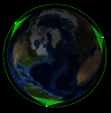
However, the Yaogan-30-01 satellites curiously do not fly in formation:


These images show that the Yaogan-30-01 trio separated, and that the satellites were placed at 120 ° from each other. As
have pointed out, they are therefore too far apart to be able to triangulate signals, since there is not even a clear line of sight between them. On the other hand, this type of arrangement corresponds to what is expected if 3 satellites are placed so as to maximize their revisit frequency.
In addition, the altitude of the orbit is curiously low for electronic listening satellites: these are usually placed relatively high, around 1000km of altitude, to increase their field of view. On the other hand, the imaging satellites are placed low, to increase their resolution while keeping an acceptable field of view. Therefore, it is doubtful that the Yaogan-30 constellation is dedicated to wiretapping: the only indications in this sense are images and official statements, which could be misinformation. The satellites could very well be small optical satellites providing a high revisit frequency.
We can also see in the first image that thanks to their low orbital inclination, the satellites have good coverage of the Pacific Ocean, India, China, North Korea and even Japan, but that the the most northern and southern parts of the globe are not covered: the satellites spend their time in the latitude band which is of interest to the defense of China.
But back to the Yaogan-30-02 trio that was launched recently:
The recent orbital data from Yaogan-30-02 shows that the satellites have started to drift relative to each other. They are already too far away to form a classic wiretapping triplet. In all probability, they will continue to drift until they are separated by 120 °, as for the previous launch. This will double the frequency of revisiting the Yaogan-30 constellation. We can represent the final orbits using the
tool
Marco Langbroek:

This kind of constellation is starting to closely resemble the
based on small satellites that are in development in the civilian world, and which have been
by DARPA in the United States. All the more if we take into account the rumors of a third launch of a Yaogan-30 trio. With 9 satellites, the constellation would have an extremely high revisit frequency:
With such a constellation, 19 passes per 24-hour period are made for a site at the latitude of Taipei (25 ° North). And these are passes with less than 45 ° of depointing, which means that the angle of view is relatively close to the vertical and therefore that the passes can be used for an imaging satellite. If we take into account a maximum deviation of 85 °, which remains usable for a wiretapping satellite, then there are up to 54 passes per 24h, and the holes in the coverage provided by the constellation last at plus 22 minutes. So there is almost constant coverage.
In conclusion, China is in the process of deploying a very high frequency revisiting constellation, in all probability for tactical use during military operations. Official statements indicate that it is a wiretap constellation. If this is the case, it would provide almost continuous coverage of regions around 30 ° North. If, on the other hand, it is in fact an imagery constellation, it will still provide an extremely high revisit frequency for the same regions. In any event, it will give China a substantial military advantage.


