China's Space Program News Thread

Status
Not open for further replies.

gelgoog

Brigadier
Registered Member
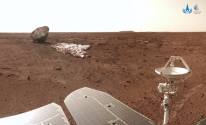
Why are China's space images always much lower resolution than the images provided by NASA? The images from their rovers are likewise very disappointing. It almost sems like it would be better if they didn't release the images at all because they suffer so much from the comparison. I can understand that they are much newer to the game, but is it really such a challenge to do imaging in space or on another planet? Is it not just a matter of using a larger sensor? Just asking out of curiosity...

The problem is bandwidth. The US has orbiting satellites on Mars which can boost the signal of the rover and send it back to Earth. China does not. If you want a high resolution image it takes forever to send one.
 

uinahime.chifune

New Member
Registered Member
Why are China's space images always much lower resolution than the images provided by NASA? The images from their rovers are likewise very disappointing. It almost sems like it would be better if they didn't release the images at all because they suffer so much from the comparison. I can understand that they are much newer to the game, but is it really such a challenge to do imaging in space or on another planet? Is it not just a matter of using a larger sensor? Just asking out of curiosity...
US has spent decades constructing the Deep Space Network (since the 1960s?)
China is just getting started
Meanwhile, there are about 4 working, previously launched US Mars orbiters in Mars orbit
China has just completed the CZ-5 for Mars exploration in recent years
Consequently, the time and bandwidth that China's Mars artifact can use for transmission is not as good as that of the US
 

Bellum_Romanum

Brigadier
Registered Member
Why are China's space images always much lower resolution than the images provided by NASA? The images from their rovers are likewise very disappointing. It almost sems like it would be better if they didn't release the images at all because they suffer so much from the comparison. I can understand that they are much newer to the game, but is it really such a challenge to do imaging in space or on another planet? Is it not just a matter of using a larger sensor? Just asking out of curiosity...
How do they "suffer" exactly, and from whom?
 

takwb

New Member
Registered Member
US has spent decades constructing the Deep Space Network (since the 1960s?)
China is just getting started
Meanwhile, there are about 4 working, previously launched US Mars orbiters in Mars orbit
China has just completed the CZ-5 for Mars exploration in recent years
Consequently, the time and bandwidth that China's Mars artifact can use for transmission is not as good as that of the US
Considering how much electronics have evolved since then, the newer equipment probably have a huge performance lead.
 

gelgoog

Brigadier
Registered Member
This photo of Pluto says otherwise.

That image was buffered. Do you know how long it took to send it back?
Please, Log in or Register to view URLs content!

"Also, at the distance of Pluto, we can only send data back at a rate that’s comparable with an old 1990s modem. Because of that, during the encounter, we’ll be taking many, many pictures, but those pictures will all be stored on the solid state memory and radioed back to the Earth months after the encounter."

The rover's camera was likely designed for faster image updates so you can navigate the rover. I doubt high image resolution was a major consideration.
 

ougoah

Brigadier
Registered Member
Bad photos on some images? Are you guys this ignorant?

The orbiter photo is of low resolution. What about these photos from the Chinese lander.

1641807843783.png

1641807870387.png

Just two scaled down photos available on media publications. There are thousands of ultra high resolution photos from China's lunar and Mars missions.

China mapped out the entire moon with greatest resolution of its entire surface back in a 2012 mission.

Please, Log in or Register to view URLs content!


The Mars orbiter photos shared have poor resolution for a few reasons. It's not necessarily the camera and it has absolutely everything to do with transmission speeds as already mentioned. They could send back a 1000x higher clarity photo of the orbiter (provided the external camera is equipped for that like the many other cameras from this mission e.g. photos above). The problem would be do they want to send that photo and wait that long for one? It's just a photo of the orbiter. There are hundreds of super high resolution photos of the surface.
 

gelgoog

Brigadier
Registered Member
Some more info.
Please, Log in or Register to view URLs content!

"New Horizons collected so much data—stored on a pair of 32-Gbit hard drives—that it will take 16 months to send it all back to Earth. And you thought the streaming speed on that True Detective episode was slow.
...
For one, consider that the information has to travel more than three billion miles. Even moving at the speed of light, that's a 4.5-hour trip for a single image.
...
Then there's the data rate challenge, says the Applied Physics Laboratory's Chris DeBoy, the lead RF (wireless and high-frequency signals) communications engineer for the New Horizons mission to Pluto. As an instrument makes an observation, data is transferred to a solid-state recorder—similar to a flash memory card for a digital camera—where it's compressed, reformatted, and transmitted to Earth through the spacecraft's radio telecommunications system, a 2.1-meter high-gain antenna. The antenna, however, has an output power of 12 watts and receives a signal from Earth that is approximately a millionth of a billionth of a watt. Taking into account the distance and low-powered signal, the New Horizons "downlink" rate is considerably low, especially when compared to rates now common for high-speed Internet, which can move information faster than 100 Mbps. New Horizons currently can only move data at a rate of 1 to 2 Kbps."
 

escobar

Brigadier
I guess, it is a spy satellite ... anybody knows in what area?
Well, finally Tianhui 4 sats mission are for gravimetry not mapping. The two have the same orbit (and very unusual being 500km non-SSO at 89°) and same adapter as NASA GRACE satellites. Gravimetry has useful applications for ballistic missile targeting and also GNSS-free positioning (especially for submarines)
 
Status
Not open for further replies.
Top