Perceived LAC is the official term used by the Indian government. India's official claims are the entirety of Aksai Chin, While China officially does not recognize Ladakh as a part of India. India's perceived LAC for the most part corresponds to where China reached in 1962, but there are some differences in perception by both sides. Once again, this is the official terminology. In areas like Galwan and Hot Springs, China's perception is west of India's, and in areas like Demchok and Pangong, India's is East of the current LAC. I
Where did India have to withdraw? In Galwan and Pangong, India withdrew from forward areas it had never occupied before. In Pangong, India had never held any position east of Finger 4, and Finger 4 effectively blocked off indian troops patrolling on foot. India only forward deployed some temporary camps near finger 4, other than that India is exactly where it was before the standoff started. China meanwhile had created permanent and strategic infrastructure all the way up to its perceived lac but had to dismantle it all and withdraw to shere it started. So status quo ante restored.
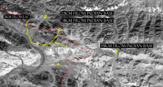
In Galwan China's perceived lac is roughly halfway within the Indian controlled portion of the valley, and its claims are even further. During the disengagement, both sides withdrew from the Indian perception of the lac, meaning China is even further back from its lac than it was before Previously India only patrolled the valley when conditions permitted, now it has permanent camps and strategic infrastructure connecting the valley to DBO all the way to the beginning of the buffer zone, which is also China's perception. This is clearly visible on google Earth. In addition, India occupied the heights adjacent to the valley, securing that portion of DBO. So how did India withdraw when in both secotors, China withdrew more? And how did the LAC change? The fact is China tried to shift the LAC westward but failed.
The noly active conflict point of the last standoff is in Hot springs, where China did come pretty close to its perception, which is roughly the confluence of the Kugrang and the Changlung. Previously, Indian patrols never went past pp15 which i roughly located around the confluence, however last summer India forward deployed beyond pp15 into China's perceived lac. During last July's disengagement, China withdrew most of its camps, and now only one Indian and one PLA camp remain in the disputed area, which lies within both the Indian and Chinese perceptions. Once again, the Indian camp is far beyond where Indian soldiers used to patrol. That standoff is still ongoing.
It would be helpful to do basic research on the subject.
For reference, this is a CIA map of the LAC as it was in the early 2000s. That line stills stands today, despite china's attempts to shift it west, even though both sides still have their perceptions/claims. There is the LAC as it stands(de facto) and the LAC both sides perceive/claim. Neither of those have changed.