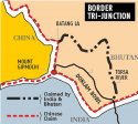
India incursion and Chinese standoff at Dolam, Bhutan

Status
Not open for further replies.

Scyth

Junior Member
I have terminal cancer and am dying from it.

I still try and come on from time to time to check things out...and what I find is that people like PD Popeye who is part of the heart and soul of this forum himself has had enough of the ridiculous nature of some of the posting going on these days.

I will try and keep things cleaned up as long as I can...and that will include keeping people from attacking those who spend sop much time trying to make SD what it is.

@bd popeye @Air Force Brat @vesicles @Deino @Obi Wan Russell @FORBIN @Jura

I'm sorry to hear that Jeff. I wish you all the strength.

Even though I wasn't an active poster. I regularly drop by and learned a lot from and enjoyed the discussions here. I believe that this is the best place for objective discussions (in English). Other forums are filled with hate, trolls, propaganda etc. I'd like to thank you and all the (former) mods for making this happen.

Thanks Jeff and all the best to you, your family and friends.
 
now I read
Chinese troops patrol control line on China-India border: FM spokesperson
Xinhua| 2017-08-16 22:16:01
Please, Log in or Register to view URLs content!

Chinese border troops have always patrolled the Chinese side of the line of control on the China-India border, said a Foreign Ministry spokesperson Wednesday in response to a recent altercation between the two troops.

According to media reports, Chinese and Indian soldiers yelled and threw stones at each other in Ladakh, a disputed area between China, Pakistan and India in southeastern Kashmir on Tuesday.

Speaking at a daily press briefing, spokesperson Hua Chunying said she was not aware of the latest reports, but added that "Chinese border troops are always committed to maintaining peace on the China-India border and always patrol along the Chinese line of control."

"We urge the Indian side to abide by the line of control agreed upon in 1959 as well as relevant regulations and conventions between the two sides, and to earnestly safeguard peace and stability in the border area," Hua said.

She also urged India to immediately and unconditionally withdraw all troops and equipment that have encroached into Chinese territory in the Dong Lang (Doklam) area.

"This is the foundation and prerequisite to the solution of the incident," Hua said.

On June 18, more than 270 Indian border troops, carrying weapons and driving two bulldozers, crossed the boundary in the Sikkim Sector and advanced more than 100 meters into Chinese territory to obstruct road construction by the Chinese side, causing tension in the area.

The trespassing Indian troops numbered as many as 400 people at one point.

As of the end of July, there were still more than 40 Indian border troops and one bulldozer illegally remaining in the Chinese territory.
 

SinoSoldier

Colonel
Was China's claim on the tri-junction based on outdated surveys?

Please, Log in or Register to view URLs content!


A very good article and extensive research done into the background of the issue, geographically-speaking.

TL;DR
  • The current dispute is about the location of the tri-junction
  • The 1890 Sino-British Treaty marks the boundary as starting from Mount Gipmochi (we'll talk about this later) and following the bifurcation of the watershed to the boundary of Nepal
  • However, old geological surveys of the location of Mount Gipmochi have been inaccurate
  • Modern maps put Mount Gipmochi at 5 km east of its original presumed location
  • Hence, the 1890 British Treaty marks the beginning of the tri-junction boundary at modern-day Batang La (as per Indian/Bhutanese claims) rather than Mount Gipmochi
  • In constructing roads into what is essentially Bhutanese territory, the Chinese have violated their 1998 agreement to maintain the status quo

Figure 1: this 1861 British map shows an inaccurate survey of the area; Mt. Gipmochi as claimed in this map should actually be Batang La in the modern day context.
Detail-of-1861-British-map.jpg

Figure 2: this modern depiction of the standoff shows the discrepancies between Chinese and Bhutanese claims. China's claims are rooted in solely the text of the 1890 Sino-British Agreement and is devoid of the context at that time.
1500397182-1162.jpg

Figure 3: the areas of interest (Gyemochen/Gipmochi, Doklam, and Batang La) are pinned. Modern maps place Gipmochi (the 19th century "Gipmochi" in this case) to be 5 km East of where it was originally thought. This means that what China claims the British have marked as the start of the boundary is actually modern day Batang La. As one can see, the Chinese road leading into the region would actually be inside Bhutanese territory in a modern context. The Chinese are merely sticking to the text of the 1890 agreement without actually looking at the locations on a similarly-dated map. By doing this, the Chinese have violated the 1998 Sino-Bhutanese agreement to maintain a status quo.
11-Screenshot-of-the-area.jpg
 

Janiz

Senior Member
After so many posts finally someone posted the truth about where this old disagreement comes from. This article is great in showing the roots of the problem that are getting destroyed by propaganda (I seriously doubt that Xinhua ever wrote that Chinese claims are coming from the treaty based on wrong names on the map...). Thanks @SinoSoldier for posting this article.
 

Hendrik_2000

Lieutenant General
That is assuming Gipmochi is the same as Gyomochen which is the Indian interpretation But the map is the mapAnyway Xinhua mock Indian transgression
And for years the Indian never dispute the Chinese possession of the disputed area How come now suddenly they come up with this excuse Another excuses from India like so many before that doesn't hold water. September is coming and if nothing is resolved it will be crunched time. Because by then the Bric conference is over and China wrap up their National congress
Another thing even if it is true it is matter between Bhutan and China how come Indian insert itself into the dispute ? It doesn't make sense contrary to international law and custom
The other principle is LOC. Disputed it maybe but it is within China LOC and as such it is defacto border pending final resolution


Separately, a Xinhua video in English, entitled “The Seven Sins of India”, accuses India of “trampling international law” and “confusing right and wrong” over the Doklam crisis.
Chinese media campaign on the Doklam crisis has become sharper, shriller, and a shade bizarre, with a daily newspaper on Thursday threatening that Chinese authorities may soon issue an “ultimatum” to India to end the Himalayan standoff.

Simultaneously, state-run Xinhua news agency released a video mocking India for ''deliberately disregarding the enormity of the mounting crisis.''

Both items allude to the urgency in defusing the crisis and avoiding a war through India’s unilateral withdrawal from the Doklam plateau.

A write-up in the state-run Global Times, which analysts say does not necessarily reflect the governmental view, asserts that China is likely to issue an “ultimatum” before September calling for the total withdrawal of Indian troops .

It quoted Xu Guangyu, a retired Rear Admiral and senior adviser to the China Arms Control and Disarmament Association, as saying that “if India keeps its troops in Chinese territory, China's foreign and defence ministries are very likely to release an ultimatum before September".

China maintains that India has infringed on its “sovereignty” in Doklam by sending its troops to stop Chinese road construction in the area. China’s position is rejected by Bhutan, which has publicly stated that the Doklam plateau is a disputed territory between the two countries.

Admiral Xu says, “The ultimatum will clearly tell India and the world that China will give a certain number of days to India to withdraw its troops. After the deadline, if Indian troops still remain within China's territory, India will be responsible for all the consequences. China has multiple ways of pushing India back to its own soil if India ignores the ultimatum, as a few dozen military personnel and one bulldozer [in Doklam] is a piece of cake for the Chinese military.”

But Admiral Xu acknowledges that “Indian troops will resist, and if there is bloodshed, China needs to be fully prepared for military conflict”.

The daily then highlights China’s combat superiority on account of its world class rocket artillery, as well as air power, relying on fighter jets, bombers and helicopters operating from “at least five large airports in Tibet”.

It also highlighted that arrangements are being made to have sufficient stocks of blood drawn from several provinces. It added that blood stocks from the recent earthquake hit area of Sichuan province were likely being transferred to Tibet.

Separately, a Xinhua video in English, entitled “The Seven Sins of India”, targeting a young foreign audience, accuses India of “trampling international law” and “confusing right and wrong” over the Doklam crisis. The presenter accuses Indian authorities of being “so thick skinned” for failing to acknowledge that they are “trampling international law” by entering “undisputed” Chinese territory.

“When the whole world is trying to wake India up from its impulse, China has realised it’s impossible to wake up a guy who is pretending to be asleep,” says the presenter. The camera than shifts to an actor, with a beard and Sikh turban. Amid canned laughter, he waggles his head and speaks English in a pronounced Indian accent.

With focus on Doklam shifting to the options of using force, an article in the state-run China Daily asks the question: “So should China use force if India continues to refuse to withdraw its troops? If yes, on what scale? And what price is it prepared to pay?”

Written by Zhou Bo, a senior Colonel in the People’s Liberation Army, the article observes that, “Excellence of weaponry is no longer a big issue for the PLA.”

It adds, “ Thanks to decades of strenuous efforts and supported by the robust Chinese economy, the Chinese defence industry has broken the technological bottleneck and the arms embargo of the West to produce some of the most advanced weapons in the world.” The writer views the Doklam crisis as a “litmus test” for the PLA.

Observers point out that amid the “saturation fire” from the state media, there is a common thread shared with the officialdom of seeking India’s unilateral withdrawal from Doklam—a position from where China, will find it hard to backtrack.
 
Last edited:
now I watched:
zdYMs.jpg

not sure what's its target market
 
Was China's claim on the tri-junction based on outdated surveys?

Please, Log in or Register to view URLs content!


A very good article and extensive research done into the background of the issue, geographically-speaking.

TL;DR
  • The current dispute is about the location of the tri-junction
  • The 1890 Sino-British Treaty marks the boundary as starting from Mount Gipmochi (we'll talk about this later) and following the bifurcation of the watershed to the boundary of Nepal
  • However, old geological surveys of the location of Mount Gipmochi have been inaccurate
  • Modern maps put Mount Gipmochi at 5 km east of its original presumed location
  • Hence, the 1890 British Treaty marks the beginning of the tri-junction boundary at modern-day Batang La (as per Indian/Bhutanese claims) rather than Mount Gipmochi
  • In constructing roads into what is essentially Bhutanese territory, the Chinese have violated their 1998 agreement to maintain the status quo

Figure 1: this 1861 British map shows an inaccurate survey of the area; Mt. Gipmochi as claimed in this map should actually be Batang La in the modern day context.
View attachment 41472

Figure 2: this modern depiction of the standoff shows the discrepancies between Chinese and Bhutanese claims. China's claims are rooted in solely the text of the 1890 Sino-British Agreement and is devoid of the context at that time.
View attachment 41473

Figure 3: the areas of interest (Gyemochen/Gipmochi, Doklam, and Batang La) are pinned. Modern maps place Gipmochi (the 19th century "Gipmochi" in this case) to be 5 km East of where it was originally thought. This means that what China claims the British have marked as the start of the boundary is actually modern day Batang La. As one can see, the Chinese road leading into the region would actually be inside Bhutanese territory in a modern context. The Chinese are merely sticking to the text of the 1890 agreement without actually looking at the locations on a similarly-dated map. By doing this, the Chinese have violated the 1998 Sino-Bhutanese agreement to maintain a status quo.
View attachment 41474

After so many posts finally someone posted the truth about where this old disagreement comes from. This article is great in showing the roots of the problem that are getting destroyed by propaganda (I seriously doubt that Xinhua ever wrote that Chinese claims are coming from the treaty based on wrong names on the map...). Thanks @SinoSoldier for posting this article.

While the article is relatively mildly biased (for something coming from Western corporate media targeting Indian and English language audiences) in describing the root of the border dispute as flawed historical evidence all around and thereby conflicting interpretations of them, it does not support your biased commentary claiming India and Bhutan's interpretation is any more valid than China's. Nor does the article claim to justify Indian aggression across an established line of control ignoring established communications protocol.
 

Janiz

Senior Member
it does not support your biased commentary claiming India and Bhutan's interpretation is any more valid than China
lol, I thought that Indian could be judged as the ones not respecting old treaties and changing them with with 'the wind' whether it blows East or West ;)
 
Status
Not open for further replies.
Top