Very far in the future, but I wonder how sensitive clocks would need to be to detect spacecraft and space stations through mass alone, and what the resolution and range would be. Technology like that would be very cool.
Atomic clocks put China’s BeiDou satnav system ahead of the rest, study finds
in Beijing Published: 7:09pm, 18 May, 2022 Updated: 7:21pm, 18 May, 2022
- Analysis of data suggests uncertainty was kept to 1 femtosecond a day – equivalent to losing or gaining a second in 30 million years
- This is something that can affect hypersonic weapons, high-speed communication, transport and even financial services

A model of China’s BeiDou satellite navigation system, which was completed in 2020. Photo: AP
China’s has achieved strong performance in atomic clock stability – something that can affect hypersonic weapons, communications and even financial services – according to a new study.
Scientists in Xian said their analysis of long-term operational data from BeiDou’s hydrogen maser clocks suggested that uncertainty was kept to 1 femtosecond per day – equivalent to losing or gaining a second in 30 million years.
That makes the atomic clocks more stable by an order of magnitude than the rubidium and cesium atomic clocks used in the US global positioning system, GPS, in the same period, according to the team led by Jia Xiaolin, a professor at the Xian Research Institute of Surveying and Mapping in Shaanxi province.
Atomic clocks in the smaller systems, the European Galileo positioning system and Russia’s GLONASS, were less stable than both BeiDou and GPS, the researchers said in a paper published in Chinese peer-reviewed journal Vacuum and Cryogenics on May 5.
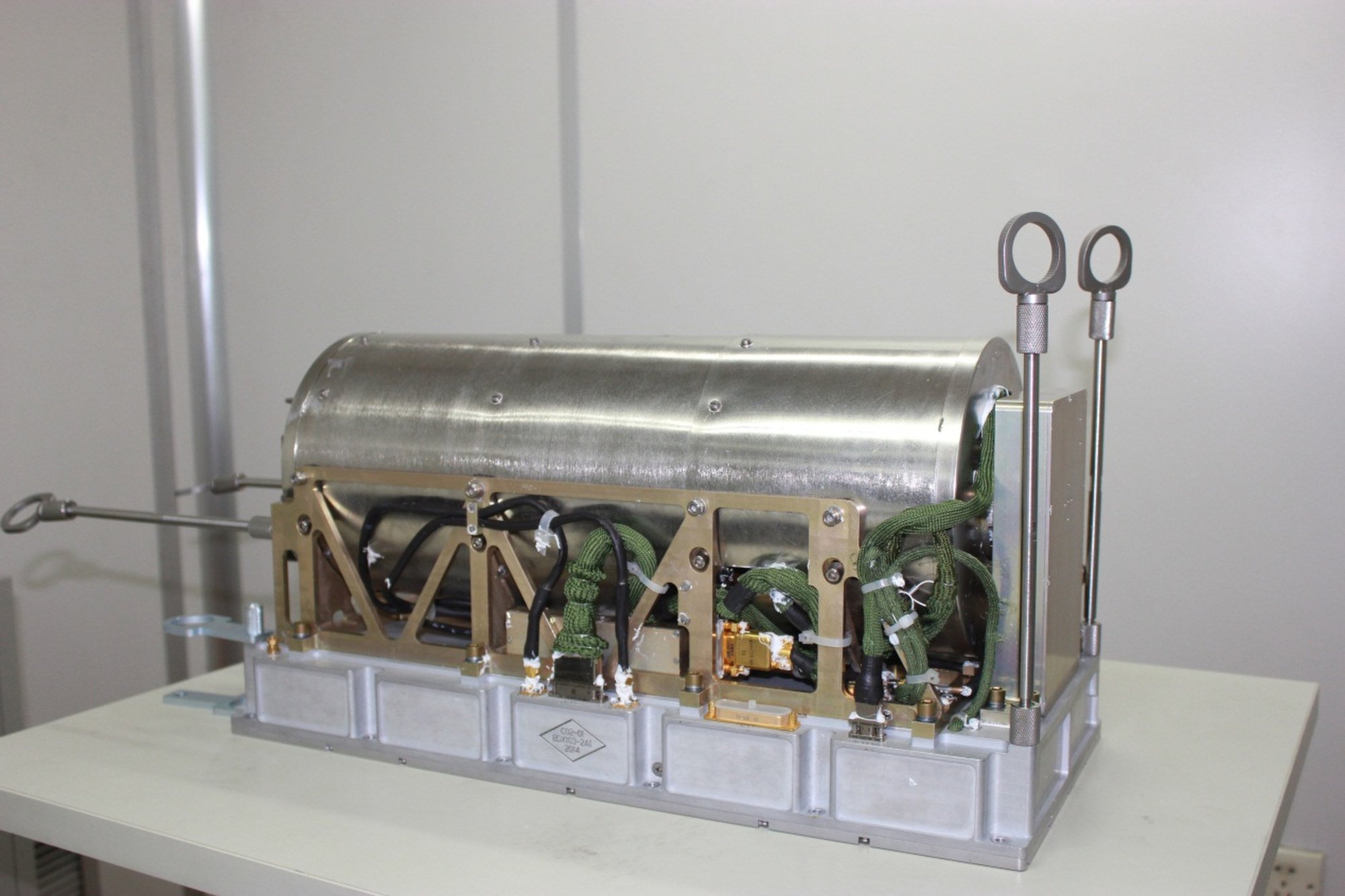
Most of the new generation BDS-3 satellites are equipped with hydrogen maser clocks. Photo: Handout
Satellite positioning works by calculating the time difference in the arrival of radio signals. So clock stability mainly affects users who need to receive positioning signals over a period of time to improve precision and reliability.
Earlier BeiDou satellites were not as precise as the GPS system for more demanding applications because their atomic clocks were less stable, according to Jia, whose institute serves the Central Military Commission’s Joint Staff Department.
The atomic clock is one of the most accurate timepieces available to humans, but the rapid oscillation of atoms in a vacuum environment used for time measurement can be easily disturbed. Mechanical vibration, heat and electromagnetic interference can all affect the behaviour of atoms.
And according to Albert Einstein’s theory of relativity, the mass of the moon, Earth or other celestial bodies can also distort space and time, introducing tiny errors that gradually build up.
Although the atomic clocks in orbit are regularly calibrated by ground controllers, an error of 100 femtoseconds accumulated in a day could cause a precision-strike weapon to miss its target by several metres, according to one estimate by Chinese military researchers.
China has been trying to improve the performance of its BeiDou system since 2017, launching a new generation of satellites known as BDS-3 that are mostly equipped with hydrogen clocks built with cutting-edge technology. Those satellites now make up 70 per cent of the constellation.
For the analysis, Jia and his team looked at the clock performance of the four global positioning systems from August 2020 to July 2021. They used data collected by the German Research Centre for Geosciences.
GLONASS was the most accurate in the span of a second, but its cesium clocks tended to make more errors than clocks in the other systems over time, the paper said.
Galileo also uses hydrogen clocks, some of which performed better than those in the BeiDou system, but with only 20 satellites in orbit the overall stability of the European system was found to be lower than the Chinese one.
The results are similar to the findings of an earlier study by researchers at the National University of Defence Technology in Changsha, Hunan province that analysed a smaller number of satellites.
A separate study by the National Time Service Centre in Xian found that BeiDou’s performance was strong enough to enable China to set up the world’s most accurate timing network. Their research suggested that the network of satellites would mean a military or business user could remain paired to Beijing Standard Time with less than 1 nanosecond of error at any location in the world, which they said was twice the accuracy of GPS.
A precise timing service has an important role in areas ranging from high-speed communication to transport, financial services and military operations.
The Chinese military, for instance, is developing a hypersonic weapon at five times the speed of sound – and the BeiDou system would provide support to achieve that over a long distance.
BeiDou has also made it possible to do things like detecting changes in shape as small as a millimetre at a dam in southwest China as a result of an earthquake over 400km away in Myanmar, according to scientists involved in the project.
The most accurate timing machine ever launched into space was a cold atomic clock on China’s Tiangong-2 space laboratory that should miss 1 second in 42 million years. That is more than four times the stability of Nasa’s most powerful space-based atomic clock, which was launched in 2019 for future deep-space missions and has uncertainty of 1 second in 10 million years.
Last month, defence contractor the Beijing Institute of Radio Metrology and Measurement said it had developed and mass-produced the world’s smallest atomic clock for missiles that is no bigger than a pack of cigarettes.
And researchers at the Chinese Academy of Sciences have said a new-generation space clock is being developed to measure the time with light and reduce the chance of error to 1 second in 30 billion years.
You are using an out of date browser. It may not display this or other websites correctly.
You should upgrade or use an alternative browser.
You should upgrade or use an alternative browser.
Chinese Satellites, Beidou Navigation System and related technologies
- Thread starter Strangelove
- Start date
Breathtaking rescue fixes satellite glitch and ensures 100% success rate of China’s BDS deployment
Star shepherds
By Fan Wei and Published: Sep 29, 2022 08:08 PM

Staffers at the Xi'an Satellite Control Center work to rescue the BDS-3 GEO-2 satellite in March 2020. Photo: Courtesy of Xi'an Satellite Control Center
"It was like a man standing upright when he was suddenly pushed to the left by an external force, and then to the right," Wang Xin, a senior engineer with the Xi'an Satellite Control Center described, as he recalled the satellite emergency in March 2020 where the second last satellite of the third generation of BeiDou Navigation Satellite System or the BDS-3 encountered an abnormal change of attitude and faced the real possibility of veering out of control.
Starting from 1994, China has sent a total of 59 BeiDou satellites into orbit in 44 space launch missions with a 100 percent success rate, and on July 31, 2020, the country announced the completion and official commissioning of the domestically developed mega space infrastructure project.
Apart from the strong performance of launch vehicles and satellites, there is a mysterious team of "star shepherd" behind the remarkable success, who are guarding China's largest satellite constellation to date around the clock.
Overcoming adversity including the COVID-19 epidemic, it was this very team that pulled off a space rescue when the BDS-3 GEO-2 satellite experienced abnormalities in March 2020 and managed to return the satellite back to its preset orbit.
A terrifying moment
China launched the BDS-3 GEO-2 satellite into a preset orbit some 200 kilometers above the ground via a Long March-3B carrier rocket from the Xichang Satellite Launch Center on March 9, 2020. As the satellite's solar panel unfolded, the launch mission marked a success.
It was the 29th member of the BDS-3 system, meaning there was but one satellite [GEO-3 to be launched in June] to go before the completion of complete deployment of all BDS-3 satellites.
By plan, the GEO-2 satellite was originally expected to carry out five orbit transfers to its final destination of geostationary orbit of 36,000 kilometers.
However, after a smooth first maneuver, an accident occurred. Remote sensing data indicated that the attitude of the satellite was reporting an abnormal change after the main satellite engine ran for more than 10 minutes.
"There was a interfering force, causing disturbance to the satellite's attitude," Wang told the Global Times.
Such an anomaly would usually lead to disastrous consequences, which according to Wang, included the damage of onboard equipment. Even worse, it could also result in a total severing of communication between the satellite and ground command, and the supporting team on the ground would not be able to monitor and control the satellite in question.
The flight control team, faced with the emergency situation, had to quickly formulate a response to rein in the satellite's attitude before it was too late.
Adding to the difficulties, due to then epidemic situation, the ground control team could not meet face to face with the satellite development team although the latter was also in Xi'an.
The ground monitoring and control team first worked out a critical value for the abnormal parameters, and when the situation hit the value, they would have to shut down the main engine to secure the satellite.
"If the parameter surpasses the critical point, the satellite would probably lose communication and control. If we did not order a shut down for the main engine, the satellite would not be able to do so once over the edge. And if that happens, we would have no knowledge over what the satellite's situation would be and where it would go," Wang explained.
Preliminary study by the team found that it was the issues with the main engine that caused the abnormal change of attitude, since it was the only propellant unit that was working. Once the main engine was shut down, the satellite would be able to hold steady.
Eventually, after five minutes into the anomaly, the parameter hit the critical value the scientists set and they made the call to shut down the main engine. And that worked to bring the situation under control.
That is to say, within only five minutes into the anomaly, we worked out the location of problem, formulated an emergency response and ran tests, and that saved the satellite from falling totally out of control, Wang recalled. "It was truly breathtaking in every step."
Following this incident, China launched the last BDS satellite in June 2020, marking the completion of the deployment of its own global navigation system.
The satellite, the 55th in the family of BeiDou which means "Big Dipper" in Chinese, was launched and sent into its preset orbit by a Long March-3B carrier rocket from the Xichang Satellite Launch Center.

Carrying the last BDS-3 satellite, a Long March-3B carrier rocket takes off from the Xichang Satellite Launch Center on June 23, 2020. Photo: VCG
The BDS system provides navigation signals across multiple frequencies, and is able to improve service accuracy by using combined multi-frequency signals.
It also integrates navigation and communication capabilities for the first time, and can provide services of navigation, short message communication, satellite-based augmentation, international search and rescue, as well as precise point positioning.
The value of China's self-developed BDS exceeded 400 billion yuan ($62.8 billion) by the end of the 13th Five-Year Plan (2016-20) period, the country's top economic planner the National Development and Reform Commission (NDRC) said in April this year.
As of the end of 2021, there have been more than 1 billion terminal devices connected to the BDS positioning service and a total of 324 million domestically made smartphones sold in 2021 applicable to the system, accounting for 94.5 percent of the total shipment of domestic smartphones.
BDS is China's largest space-based system and one of four global navigation networks alongside the US' GPS, Russia's GLONASS and the European Union's Galileo. BDS can provide diverse services and powerful functions. Globally, it can provide services enabling positioning, navigation and timing, global message communication, and international search and rescue. In the Asia-Pacific region, its services include regional short message communication, precise point positioning, and satellite-based and ground-based augmentation.
Making things right in 20 days
Rescuing the satellite from going out of control was only the start. As the most versatile, largest type of satellite with longest service life, the BDS-3 GEO satellite was too expensive to give up.
Starting from November 11, 2017, China scheduled a tight 18 launches for 30 BDS-3 satellites in a period just slightly over two years.
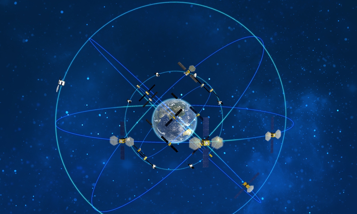
Illustration of BDS-3 system
Besides, "it would take another year to launch a back-up GEO-2 satellite, and that would delay the goals of deploying all BDS-3 satellites within 2020," Wang said.
The Xi'an ground monitoring and control team, after resolving the crisis, conducted a detailed analysis with the satellite development team. They located and identified the malfunction as being burn-through at the effuse at the main engine.
The team faced two options to recover the satellite that was in the some 6,000 kilometers transfer orbit to the destination GEO. One was to try to restart the main engine following the previous plan and the other was more complex yet less risky - using smaller propellant units that were tasked for attitude control to reach its goal.
See link for rest of article...
Remote-sensing satellite center to further China's socioeconomic growth
By ZHANG ZHIHAO | chinadaily.com.cn | Updated: 2022-09-27 17:52
The Chinese Academy of Sciences launched the National Engineering Research Center for Remote Sensing Satellite Applications in Beijing on Tuesday, with goals of making more breakthroughs in core technologies, training quality engineering talent and harnessing the potential of satellite technologies to support the nation's major strategic needs.
These needs range from China achieving its carbon dioxide emission peak and carbon neutrality goals to managing smart cities and natural resources, said Gu Xingfa, the director of the researcher center.
"Remote sensing has become an essential technology for a country's development and administration," he added.
China currently has more than 300 satellites in orbit, second only to the United States. The performance and quality of Chinese satellites are catching up, some of which are even surpassing their Western counterparts, Gu said.
China's remote sensing satellite industry is booming fast and has served many industries.
"It is now an indispensable tool for socioeconomic development," he said.
However, managing the massive amount of data and user needs is a major challenge. To that end, the center has launched a new service platform by analyzing about 140 fields in which remote-sensing satellites are needed.
The platform will provide 24 remote-sensing data products ranging from vegetation to atmospheric data that will be useful in environmental protection, rural development, resource management, disaster migration and other fields, Gu said.
BDS satellite navigation system bolsters Chinese online map app’s positioning capability
By Global Times Published: Oct 12, 2022 07:32 PM

Aerial photo taken on Aug 26, 2022 shows a car arriving at the Shuangbai toll station of the Yuxi-Chuxiong Expressway in southwest China's Yunnan Province.Photo:Xinhua
The daily positioning volume of China's homegrown BeiDou Navigation Satellite System (BDS) during the National Day holidays exceeded 150 billion times, an increase of more than 50 percent compared with the pre-holiday period, China's tech giant Baidu said on Wednesday.
The data came after Chinese online map Baidu Maps announced an official switch to the Beidou priority positioning on September 30, with daily positioning volume exceeding 100 billion times for the first time. The company said 97.81 percent of positioning had achieved BDS priority.
Integrated with the BDS system, the app has also upgraded other functions such as lane-level and parking-level navigation.
The China-developed BDS, which has also served global users for more than two years, has been deeply integrated into and applied to industries such as transportation, disaster prevention and mitigation, agriculture, forestry, animal husbandry and fishing, and power and communication.
BDS is an important component of Chinese space information infrastructure and has become a powerful symbol of China's science and technology capability, in addition to being the cornerstone of the country's national security.
Baidu Maps said it has launched map navigation and positioning services based on the system and had strengthened integration over recent years.
In addition to map navigation, Baidu said the system has also served more than 2.55 million developers across an array of industries, including auto-making, travel, and finance.
The National Development and Reform Commission (NDRC) said in April that the value of BDS exceeded 400 billion yuan ($57 billion) as of the end of the 13th Five-Year Plan (2016-20) period. At the end of 2021, there were more than 1 billion units and terminals using the BDS positioning function nationwide, NDRC said.
On July 31, 2020, China officially commissioned the BDS, opening the new BDS-3 system to global users.
I have read that Beidou's positioning accuracy for military use is actually superior to that of GPS. What the real numbers are who knows. Glonass would be inferior to both in this regard, but recently China agreed to build 3 ground stations for Glonass in China, while Russia will let China build 3 Beidou stations in Russia.Beidou is truly a technical masterpiece and one crown jewel in China's tech domain.
I recall learning about some of its details years ago in a GNS class on surveying and commercial SAR technology. Beidou AKA "Compass" came up as a topic one day and we were lucky enough to have someone who worked closely on it talk about some of its technical details. Most of it is public domain but after a comparison of its capabilities and functions, it's clear Beidou is superior to GPS (back then without anywhere near as many number of satellites in its constellation though) and leaves Galileo and Glonass so far in the dust in both technology and number of satellites (this would have been around 10 years ago). These systems are not comparable. China truly did something remarkable with Beidou.
A couple of reasons to cooperate with Russia on Glonass: 1.) Glonass has better coverage of higher latitudes, whereas Beidou is strong on mid to lower latitude coverage like GPS. 2.) To serve as backup
In the future, there may be a scenario where all GPS signals get cut off by the US. Better to have both Beidou and Glonass receiving ability installed in something like commercial airlines.
China’s next-gen BeiDou satellites reach for the moon – and your mobile
- New technologies will extend the satnav system to include underwater communications and deep space, with ‘unprecedented accuracy’
- Mobile phone access in remote parts of the Earth will also be enhanced, programme chief says
China is developing a new generation of satellites for its system that will give unprecedented accuracy and coverage for a range of services, including mobile phone access, according to the programme chief.
Ran Chengqi, director of the China Satellite Navigation Office, said the new global positioning system, tentatively named BeiDou 4, would extend its services to include underwater communications and deep
China sent a new communications satellite into orbit from the Xichang Satellite Launch Center in southwest China's Sichuan Province on Saturday.
The "ChinaSat 19" satellite was launched at 7:50 p.m. (Beijing Time) by a Long March-3B carrier rocket.
The satellite will mainly provide communication services for the important routes across the Pacific, the eastern Pacific Ocean and the west coast of North America.
The launch marks the 447th mission of the Long March carrier rocket series.
BeiDou making mark among navigation systems
By ZHU WENQIAN in Wuzhen, Zhejiang | China Daily | Updated: 2022-11-10 11:09

China's BeiDou Navigation Satellite System (BDS) will be further developed and feature better compatibility and interoperability coordination with the world's other navigation systems, including the GPS system of the United States, Russia's GLONASS system and the Galileo system of the European Union, an official said during the World Internet Conference Wuzhen Summit in Zhejiang province on Wednesday.
BDS operators will regard bilateral and multilateral cooperation with other systems in the application sectors as an important matter, continue to promote the implementation of some application demonstration projects overseas and practically push forward its international applications, Ran Chengqi, director general of China Satellite Navigation Office, said at a forum during the summit.
"BDS has made significant contributions to the digitalization of economies involved in the Belt and Road Initiative, and it has provided effective and accurate services to more than half of countries and regions worldwide," Ran said.
BDS has released its cooperative initiatives and application scenarios to countries in Africa, Central Asia and Latin America, as well as member states of global organizations like the League of Arab States and the Association of Southeast Asian Nations.
Launched in July 2020, BDS is regarded as one of the four core satellite navigation systems globally. The technology has entered a new stage and is set to play a more important role with the fast development of the global digital economy, and BDS has been adhering to opening-up and cooperation, Ran said.
"Next, we will continue to promote the construction, development and capacity upgrading of BDS, and provide support for future intelligent and unmanned development. In the future, no matter whether the facilities are underwater, indoors or in deep space, we will be able to enjoy highly precise, safe and intelligent positioning and navigation services."
Besides providing positioning and navigation services to global users, BDS has its own innovations and featured services such as providing highly accurate services for bike-sharing management, he added.
For example, the service helps manage precise locations of shared bicycles nationwide. Currently, China has some 1.1 million bicycles available for sharing that the high-accuracy service of BDS can precisely manage locations of.
Last year, China had some 3.8 million bikes available for bike-sharing services, according to research firm iiMedia Research.
Meanwhile, the State Council Information Office published a white paper titled "China's BeiDou Navigation Satellite System in the New Era" on Friday.
As a first-class navigation satellite system developed by China and dedicated to the world, BDS has been applied worldwide, integrated with global infrastructure and introduced into mass markets, empowering industries and profoundly changing people's lives and the way they work, the white paper said.
According to the white paper, in the years to come, China will further upgrade BDS technologies, functions and services. The goal is to create a comprehensive system that is more extensive, integrated and intelligent, and that provides flexible, smart, precise and secure navigation, positioning and timing services. And by doing so, China will be able to better help improve people's well-being and promote human progress.
In addition, China will promote large-scale BDS applications and encourage their market-oriented, industrialized and globalized development to offer a broader range of public services at a higher quality, the white paper said.
Robot prototype capable of clearing space debris shines at Airshow China
By in Zhuhai Published: Nov 13, 2022 09:44 PM
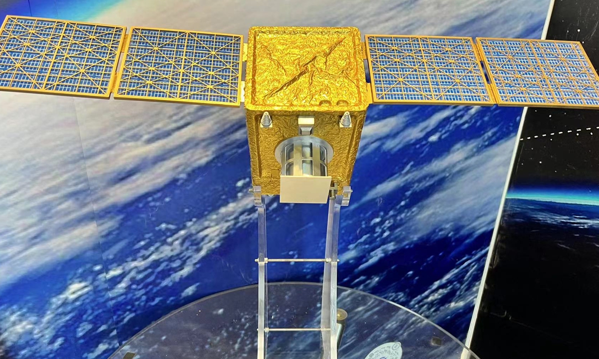
Model of the NEO-01 is displayed at Airshow China in Zhuhai, South China's Guangdong Province. Photo: Cao Siqi/GT
The model of a robotic platform that had been launched into low-Earth orbit by a Chinese space-mining start-up made its debut at Airshow China, drawing wide attention from space fans for its wild vision of how to lead the world on space debris removal techniques and to pave the way for technologies capable of mining on asteroids.
The NEO-01, developed by Nanjing-based Origin Space Technology Co, which claims to be the first Chinese company dedicated to exploring and utilizing space resources, was launched on a Long March 6 rocket for space debris removal and asteroids mining experiments in deep space in April 2021.
The Global Times learned from the company at the air show that the robot prototype completed an experiment of using a large net to capture space debris and the relative technique verification in key steps, which is the first commercial company in the world to complete such an experiment.
"In the future, the NEO series satellites could clear space debris by dragging it out of orbit and burning it in atmosphere, and accurately capture space debris that may pose a threat to space spacecraft and other targets to protect the safety of space facilities," Su Meng, founder and CEO of Origin Space, told the Global Times on Sunday.
Since the establishment of the world's first asteroid mining company Planetary Resources in 2009, more than a dozen firms across the world have entered the sector.
Pieces of space debris, space junk and other debris left in orbit that are no longer controlled will pose a major threat to normal spacecraft. Data show that nearly 80 percent of the cataloged objects in orbit are space debris, and the number of uncontrollable space objects is surprisingly large.
The vast space is no longer quiet, space traffic has become busy and space junk will lead to "space car accidents." Space debris removal is urgent, Su noted.
According to Su, by 2025, there are likely to be more than 50,000 satellites in orbit and the amount of space junk will be ten times larger than today. Su vows to build his company into the world's top one with the capability to clear space debris.
On June 22, 2021, Origin Space launched the commercial space telescope Yangwang-1 into orbit from the Taiyuan Satellite Launch Center in North China's Shanxi Province.
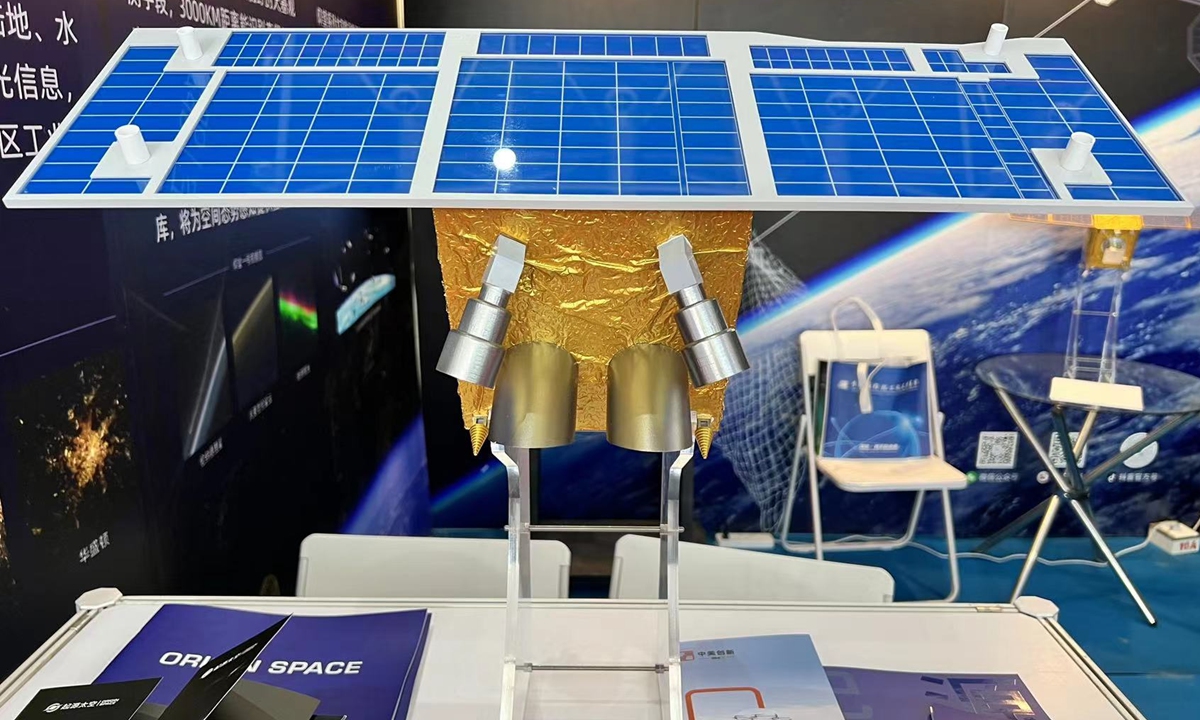
Model of commercial space telescope Yangwang-1 Photo: Cao Siqi/GT
During its stay in orbit, Yangwang-1 carried out astronomical, asteroid and space debris observations.
At present, 90% of mobile phones in China and 50% of those in the world can receive signals from China's BeiDou Navigation Satellite System (BDS), said the deputy chief designer of the system on Thursday, adding BDS-related products have entered over 120 countries and regions...
