
You are using an out of date browser. It may not display this or other websites correctly.
You should upgrade or use an alternative browser.
You should upgrade or use an alternative browser.
China's Space Program News Thread
- Thread starter crazyinsane105
- Start date
- Status
- Not open for further replies.
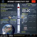
It's the second launch in the same day and fifth in August.China launches new communication technology experiment satellite
Some photos:


Sounds like Scolese needs to continue continually innovating.
It's the second launch in the same day and fifth in August.
Some photos:
View attachment 76493
View attachment 76494
View attachment 76495
Attachments
-
 IMG_20210825_064130.jpg232.2 KB · Views: 43


by78
General
A proposal for a disaster monitoring satellite network. The 36-Tiangang (36天罡) satellite constellation is composed of satellites equipped with panchromatic multi-optical, hyperspectral imaging, SAR, and laser multi-beam scanning payloads. When combined with LiDar and high-resolution optical photography from UAVs, the satellite constellation can fulfill the role of low-orbit small remote-sensing satellites. The constellation is flexible and can perform orbital changes quickly, thereby providing fast real-time coverage. Analysis of sensor data is to be carried out by ground stations, providing an integrated monitoring and early warning system for disaster management and emergency response.


- Status
- Not open for further replies.