Borders of MR

Deino

Lieutenant General
Staff member
Super Moderator
Registered Member
Not sure if it's here the correct tread but since I'm interested in the PLAAF-MR-borders ... Once again me with a strange / stupid question but a comparison of the MR borders, which were published in several "sources", they differ quite a lot :screwy: (and not only thru their gestation to the current 7 MR's).

Esp. the Lanzhou MR, Chengdu MR and Beijing MR are quite different. :confused:

I know they were changed several times and originally did not fit the provincial borders ... but as far as I know this was later changed and they are currently.

As such I agree with "franco-russe":

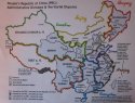
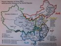
I am still a bit confused about the division of Inner Mongolia and I do not know about prefectures.

But the MR's are basically made up of provinces (and equivalent administrative bodies) as follows:

Shenyang MR: Liaoning, Heilongjiang, Jilin
Beijng MR: Beijing, Tianjin, Hebei, Shanxi, Inner Mongolia
Lanzhou MR: Gansu, Shaanxi, Qinghai, Ningxia, Xinjiang
Jinan MR: Shandong, Henan
Nanjing MR: Jiangsu, Anhui, Zhejiang, Jiangxi, Fujian, Shanghai
Guangzhou MR: Guangdong, Guangxi, Hubei, Hunan, Hainan
Chengdu MR: Sichuan, Yunnan, Guizhou, Chongqing, Tibet

Can anyone help me out, what are the correct current ones ....

Thanks in advance,
Deino :)
 

Attachments

  • PLAAF - MR question.jpg
    PLAAF - MR question.jpg
    152.7 KB · Views: 26

Deino

Lieutenant General
Staff member
Super Moderator
Registered Member
Hey ... no one ???? :(

I just tried to "create" my version ... what do You think ? :confused:

Deino :)


PS: added is also an attempt to draw the "maybe" future with the re-structured orga as mentioned some time ago to 5 Stratigic zones (anyway, what happend with this ??) But please ommit the mistake I did with the Hubei Prov ... should be yellow.
 

Attachments

  • PLAAF - MR own version 1.jpg
    PLAAF - MR own version 1.jpg
    107.8 KB · Views: 20
  • PLAAF - SZ own version 1.jpg
    PLAAF - SZ own version 1.jpg
    105.4 KB · Views: 14

i.e.

Senior Member
Hey ... no one ???? :(

I just tried to "create" my version ... what do You think ? :confused:

Deino :)


PS: added is also an attempt to draw the "maybe" future with the re-structured orga as mentioned some time ago to 5 Stratigic zones (anyway, what happend with this ??) But please ommit the mistake I did with the Hubei Prov ... should be yellow.

compare with the two...

the reason Chengdu and Lanzhou is two seperate region because of Geography and Logistics.

The primary base for operation in Tibet and Yunnan is Sichuan, from Xinjiang to TIbet the lines of communication is exterior, close to the border and easy to close down in a conflict.

from Sichuan it is interior lines of communication.

Over lay the railway lines in china, you will see why Xinjiang and Lanzhou, the HeXi Corridor has traditionally been a military artery to project chinese military power into central asia for close to 1.5 millenia.

Why Beijing is included with I. Mongolia?
because traditionally the threat to Beijing has alway s came fro north. it is merely 1.5 hours drive from Beijing to Flatlands of I. M.
again geography.

Shenyang MR's responsibilty is to defend. HLJ from russians, and as base of intervention in case of Korean War 2.
again geography, the population and rail lines are extensive in souther Manchuria extending into HLJ province, not so in north east part of Inner Mongolia. and it is again exterior lines from major logistics centers into North.
 

Deino

Lieutenant General
Staff member
Super Moderator
Registered Member
@ i.e. ! Thanks, but maybe may request was a bit mislading !

I was not questioning why Chengdu and Lanzhou are two seperate regions and also why Beining and/or Mongolia, but why they are shown in the maps in my first so different and most of all, WHAT's the correct current map ??

Deino
 

i.e.

Senior Member
@ i.e. ! Thanks, but maybe may request was a bit mislading !

I was not questioning why Chengdu and Lanzhou are two seperate regions and also why Beining and/or Mongolia, but why they are shown in the maps in my first so different and most of all, WHAT's the correct current map ??

Deino

donno.

why do any one care? :)
 

Deino

Lieutenant General
Staff member
Super Moderator
Registered Member
donno.

why do any one care? :)

To admit, I need to do a completely new map of the current status for a publication I prepare right now and as such I wanted to be sure that the borders are correct as they look like today !

Deino
 

Deino

Lieutenant General
Staff member
Super Moderator
Registered Member
Just some additional posts (via CDF - from "Bueller"):

AFAIK, the black and white looks about right. Beijing MR doesn't have the far eastern portion of Inner Mongolia, Shenyang does, and Chengdu MR doesn't have the Ngari Prefecture, Lanzhou does.

There are minor discrepancies between MR borders and administrative borders. LZMR's Tibetan portion was taken by troops from the the Xinjiang MR and subsequently supplied by XJMR to safeguard the XJ-Tibet highway through Askai Chin. Now onto Inner Mongolia. Its eastern tip faces Russia rather than Mongolia and is actually controlled by SYMR. Its far western portion is also garrisoned by units of the LZMR's 21st Army.

There are also other discrepancies wrt Wuhan MR being split into portions of Jinan and Guangzhou MR.

What I'm saying is that military regions does not adhere to administrative borders. They are independent of each other. When they do coincide with each other, it's out of convenience.


As such maybe this system is too "strange" for me to fully understand it; ... sorry for being a bit "slow" in understanding.:(

Deino
 

CottageLV

Banned Idiot
southwest xinjiang, aka Ali region, is under control of Chengdu region, due to its high altitude. politically its under xinjiang, but geologically its part of tibetan plateau i believe.
 
Top