I don't get your point. I assume almost everyone knows that 056 doesn't have hangar. But it does have take-off/landing platform, which is what I'm asking (not to be neglected if Z-9 is to be replaced). Again, perhaps I do miss what you want to say...... and Type 056 don' t have hangar !!! ...

You are using an out of date browser. It may not display this or other websites correctly.
You should upgrade or use an alternative browser.
You should upgrade or use an alternative browser.
PLAN Naval Helicopter & ASW Capability II
- Thread starter bd popeye
- Start date
Both the Z-15 and the Z-20 will land on the 056 just fine (the Z-20 would have to be navalized with its tail wheel moved forward like in the SH-60). The 056 helipad has the sufficient length to land these helicopters as much as any other PLAN ship. It only lacks in beam (and only compared to other larger ships), which for these helos should also not a problem.I have no comment on PLAN next gen ASW helo. Simply want to see the possibility Z-9 to be replaced. According to above discussions, it's still open what will fit 056 after Z-9. So far, while PLAN been decisive in retiring some old platforms before life cycle, eg 053H2G & 022, it also had been thrift in many equipments such as CIWs.
Hendrik_2000
Lieutenant General
By itself the robot is not a weapon or sensor.But in order to buil the infrastructure of underwater great wall you need the tool And that is exactly what this robot is for.So today news in the success of deep sea robot and test of deep sea Li Ion battery is a big step in realization of underwater great wall
Those UUV will eventually running out of juices they need to be recharged. Those listening post need to be connected with fiber optic to form network and buried under the sand
Here is the actual video of deep sea robot
And here is the robot in work to lay cable and buried it under the sand
Test of new deep sea Lithium ion battery
And here the future look like for underwater great wall
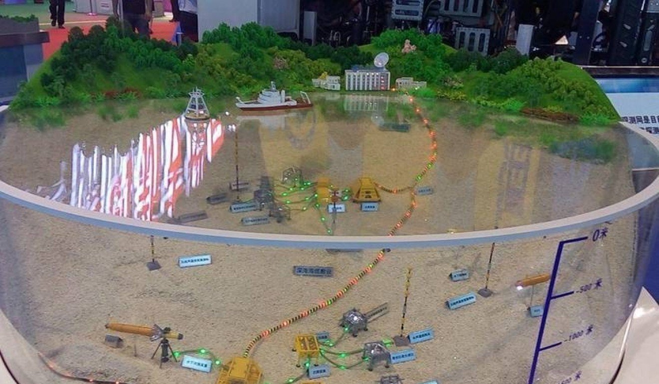
The Great Underwater Wall Of Robots: Chinese Exhibit Shows Off Sea Drones
Chinese Robot Submarines Blanketing the Ocean Floor Soon
By June 22, 2016

Underwater Great Wall of China
The Underwater Great Wall may be centered around stationary sensors on the ocean bed, but autonomous unmanned underwater vehicles will be a critical enabler in not just tracking enemy submarines, but finding them. Also note the large AUV's reflection on the display glass.
The Chinese Navy, the PLAN, appears to be following in the footsteps of its sister service, the People's Liberation Army Air Force, in making growing investments in unmanned surface and underwater systems, aka "drones." A new Chinese exhibit shows the scale of the potential future.

A Wide Range of UUVs
China is experimenting in building autonomous UUVs of all shapes and sizes, looking to make them work together with each other, and Chinese warships too.
One area where unmanned underwater vehicles (UUV) and unmanned surface vehicles (USV) would make a splash is in Chinese anti-submarine warfare (ASW) efforts. ASW capabilities have been a longstanding weak spot for the PLAN, leaving it at a disadvantage to American and Japanese attack submarines. As a response, the China State Shipbuilding Corporation (CSSC), which builds virtually all PLAN warships, has proposed an "Underwater Great Wall" of sensors, positioned on the seabed floor, to listen for enemy submarines. (The US had a similar system on the Atlantic Ocean floor to listen for Soviet submarines.) Such underwater listening posts may already have been installed near the giant PLAN base at Sanya, Hainan Island in the South China Sea. On a more optimistic note, CSSC suggested that an Underwater Great Wall would be useful for warning against natural disasters like tsunami, and could be used to collect research data on marine life and geology.

System of Systems
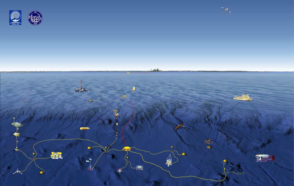
Future Chinese anti-submarine warfare systems will rely on a wide arsenal of autonomous and surface unmanned vehicles, in addition to acoustic (and other types of) sensors installed on the ocean floor.
In addition to active and passive sensors located up to 3,000 meters underwater, the Underwater Great Wall will be supported by a wide range of USVs. Chinese researchers intend that these autonomous USVs will be able to work in conjunction with the seabed sensor picket line, and autonomously locate and track enemy submarines.
Those UUV will eventually running out of juices they need to be recharged. Those listening post need to be connected with fiber optic to form network and buried under the sand
Here is the actual video of deep sea robot
And here is the robot in work to lay cable and buried it under the sand
Test of new deep sea Lithium ion battery
And here the future look like for underwater great wall
The Great Underwater Wall Of Robots: Chinese Exhibit Shows Off Sea Drones
Chinese Robot Submarines Blanketing the Ocean Floor Soon
By June 22, 2016
Underwater Great Wall of China
The Underwater Great Wall may be centered around stationary sensors on the ocean bed, but autonomous unmanned underwater vehicles will be a critical enabler in not just tracking enemy submarines, but finding them. Also note the large AUV's reflection on the display glass.
The Chinese Navy, the PLAN, appears to be following in the footsteps of its sister service, the People's Liberation Army Air Force, in making growing investments in unmanned surface and underwater systems, aka "drones." A new Chinese exhibit shows the scale of the potential future.
A Wide Range of UUVs
China is experimenting in building autonomous UUVs of all shapes and sizes, looking to make them work together with each other, and Chinese warships too.
One area where unmanned underwater vehicles (UUV) and unmanned surface vehicles (USV) would make a splash is in Chinese anti-submarine warfare (ASW) efforts. ASW capabilities have been a longstanding weak spot for the PLAN, leaving it at a disadvantage to American and Japanese attack submarines. As a response, the China State Shipbuilding Corporation (CSSC), which builds virtually all PLAN warships, has proposed an "Underwater Great Wall" of sensors, positioned on the seabed floor, to listen for enemy submarines. (The US had a similar system on the Atlantic Ocean floor to listen for Soviet submarines.) Such underwater listening posts may already have been installed near the giant PLAN base at Sanya, Hainan Island in the South China Sea. On a more optimistic note, CSSC suggested that an Underwater Great Wall would be useful for warning against natural disasters like tsunami, and could be used to collect research data on marine life and geology.
System of Systems
Future Chinese anti-submarine warfare systems will rely on a wide arsenal of autonomous and surface unmanned vehicles, in addition to acoustic (and other types of) sensors installed on the ocean floor.
In addition to active and passive sensors located up to 3,000 meters underwater, the Underwater Great Wall will be supported by a wide range of USVs. Chinese researchers intend that these autonomous USVs will be able to work in conjunction with the seabed sensor picket line, and autonomously locate and track enemy submarines.
Last edited:
Hendrik_2000
Lieutenant General
China plan to build underwater sensor network Dirst posted by Vincent at CDF
项目总投资超20亿元,建设周期5年。观测网建成后将实现中国东海和南海从海底向海面的全天候、实时和高分辨率的多界面立体综合观测,从而推动科学前沿研究,并服务于海洋环境监测、灾害预警、国防安全与国家权益等多方面的综合需求。
海底科学观测网是人类建立的第三种地球科学观测平台,通过它人类可以深入到海洋内部观测和认识海洋。目前,北美、西欧和日本等十几个国家都已经拥有海底观测网。记者日前获悉,我国国家海底科学观测网日前正式被批复建立。
国家海底科学观测网是国家重大科技基础设施建设项目,将在我国东海和南海分别建立海底观测系统,实现中国东海和南海从海底向海面的全天候、实时和高分辨率的多界面立体综合观测,为深入认识东海和南海海洋环境提供长期连续观测数据和原位科学实验平台。同时,在上海临港建设监测与数据中心,对整个海底科学观测网进行监控,实现对东海和南海获取的数据进行存储和管理。从而推动我国地球系统科学和全球气候变化的科学前沿研究,并服务于海洋环境监测、灾害预警、国防安全与国家权益等多方面的综合需求。
同济大学海洋与地球科学学院教授 周怀阳:这个系统建立以后,除了科学研究以外,还能够给其他生产应用部门,像地矿、测绘或者海洋权益、国防安全,应该都有一些辐射作用。我们呼吁国家各个部门能够联合起来,制定更加严格的保护水下长期设施的各种各样的政策和措施,能够使得我们这个系统能够在水下长期地运行。
国家海底科学观测网项目总投资超20亿元,建设周期五年。(央视记者 高磊)
Passable google translation
The total investment of the project is over 2 billion yuan and the construction period is 5 years. After the completion of the observation network will be completed in China's East China Sea and the South China Sea from the sea to the sea all-weather, real-time and high-resolution multi-interface three-dimensional comprehensive observation, to promote scientific frontier research and services in marine environmental monitoring, disaster warning, national security and national rights And so on a wide range of comprehensive needs. The submarine scientific observation network is the third earth observation platform established by mankind, through which human beings can penetrate into the ocean to observe and understand the ocean. At present, North America, Western Europe and Japan, more than a dozen countries already have submarine observation network. Reporters recently learned that China's national submarine scientific observation network has recently been formally established. National submarine scientific observation network is a major national science and technology infrastructure projects, will be in the East China Sea and the South China Sea were established underwater observation system to achieve the East China Sea and the South China Sea from the sea to the sea all-weather, real-time and high-resolution multi- For the deep understanding of the East China Sea and the South China Sea marine environment to provide long-term continuous observation data and in situ scientific experimental platform. At the same time, in Shanghai port construction monitoring and data center, the entire submarine scientific observation network monitoring, to achieve the East China Sea and the South China Sea to obtain the data storage and management. So as to promote the scientific research of China's Earth system science and global climate change and serve the comprehensive needs of marine environmental monitoring, disaster early warning, national defense security and national rights and interests. Professor Tong Huaiyang, Professor of Ocean and Earth Sciences, Tongji University After the establishment of this system, in addition to scientific research, but also to other production and application departments, such as mining, mapping or marine rights and interests, national defense, should have some radiation. We call on the various departments of the country to unite to develop more stringent policies and measures to protect underwater long-term facilities, enabling our system to run underwater for long periods of time. National submarine scientific observation network project total investment over 2 billion yuan, the construction period of five years. (CCTV reporter Gao Lei)
Google Translate for Business:Translator ToolkitWebsite TranslatorGlobal Market Finder
About Google TranslateCommunityMobileAbout GooglePrivacy & TermsHelp
China plan to build underwater sensor network Dirst posted by Vincent at CDF
项目总投资超20亿元,建设周期5年。观测网建成后将实现中国东海和南海从海底向海面的全天候、实时和高分辨率的多界面立体综合观测,从而推动科学前沿研究,并服务于海洋环境监测、灾害预警、国防安全与国家权益等多方面的综合需求。
海底科学观测网是人类建立的第三种地球科学观测平台,通过它人类可以深入到海洋内部观测和认识海洋。目前,北美、西欧和日本等十几个国家都已经拥有海底观测网。记者日前获悉,我国国家海底科学观测网日前正式被批复建立。
国家海底科学观测网是国家重大科技基础设施建设项目,将在我国东海和南海分别建立海底观测系统,实现中国东海和南海从海底向海面的全天候、实时和高分辨率的多界面立体综合观测,为深入认识东海和南海海洋环境提供长期连续观测数据和原位科学实验平台。同时,在上海临港建设监测与数据中心,对整个海底科学观测网进行监控,实现对东海和南海获取的数据进行存储和管理。从而推动我国地球系统科学和全球气候变化的科学前沿研究,并服务于海洋环境监测、灾害预警、国防安全与国家权益等多方面的综合需求。
同济大学海洋与地球科学学院教授 周怀阳:这个系统建立以后,除了科学研究以外,还能够给其他生产应用部门,像地矿、测绘或者海洋权益、国防安全,应该都有一些辐射作用。我们呼吁国家各个部门能够联合起来,制定更加严格的保护水下长期设施的各种各样的政策和措施,能够使得我们这个系统能够在水下长期地运行。
国家海底科学观测网项目总投资超20亿元,建设周期五年。(央视记者 高磊)
Passable google translation
The total investment of the project is over 2 billion yuan and the construction period is 5 years.
2 billion yuan is pretty cheap considering a single 055 is 6 billion yuan.
Hendrik_2000
Lieutenant General
SCMP report on the plan of a new underwater great wall apparently it is related to the proposal by chinese firm reported earlier go back couple page or click the link below. But why SCMP need to bring up the SCS dispute? It has no relation so what who care if it upset somebody
China plans to build a massive underwater observation system that will cover the disputed East and South China seas.
The 2 billion yuan (US$290 million) seabed observation systems will provide real-time information about the environmental conditions and seabed activities at a time when China is expanding its presence in both the East and South China seas.
The central government recently approved the plan which would take five years to build and implement, state broadcaster CCTV reported.
A data centre will also be built in Shanghai to monitor and store the chemical, biological and geological information collected from the underwater systems.
Such systems would not only help China advance in scientific research and disaster prevention, but help protect national security, the report said.
Zhou Huaiyang, a professor at the School of Marine and Earth Science at Tongji University, said in the report that the collected data could be passed to other government departments to explore natural resources and protect China’s maritime interests and national security.
But the move is more likely to cause alarm among China’s neighbours as it continues to strengthen its civilian and military presence in the South China Sea.
Hendrik_2000
Lieutenant General
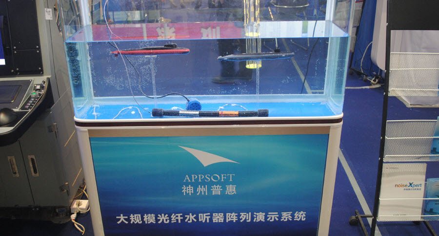
The acoustic sensor of the large-scale fiber optic network project has just passed the initial acceptance phase.
Hendrik_2000
Lieutenant General
China 's Navy - South China Sea Fleet: Submarine aircraft to carry out comprehensive anti - submarine training
China 's Navy - South China Sea Fleet: Submarine aircraft to carry out comprehensive anti - submarine training
specifically, it shows involvement of a Y-8GX6 as part of the exercise
