Jura The idiot
General
Ha, well you brought Stalingrad up.
...
something more recent, then (no more from me after this one):
again off top of my head, sometime in August (?), 1941 Zhukov was sent to Leningrad to defend it, and ...
... cheers

Ha, well you brought Stalingrad up.
...
something more recent, then (no more from me after this one):
again off top of my head, sometime in August (?), 1941 Zhukov was sent to Leningrad to defend it, and ...
...
I was wondering how big Units take part in the action I tried to describe here recently, I mean attacking in respective directions; from maybe two or three attacks which failed, I saw some numbers reported and pictures/videos taken of KIAs, and if I believed this, the number would up to around one hundred; this would mean something between a Battalion-strength and Regiment-strength if assuming about 10% KIAs before such an attack was aborted, but it's just my armchair-generalling look which may be completely off, as I don't know what tactics is actually used there etc. But I've read both the Regular Army and ISIL commanders are experienced (former Iraqi Army in the case of ISIL), graduates of Russian-style Military Academies etc. so the attacks are planned and executed thoughtfully (I don't mean to be cynical or nothing). Will somebody comment on this? Also if you think it's nonsense what I said, just tell me.
")
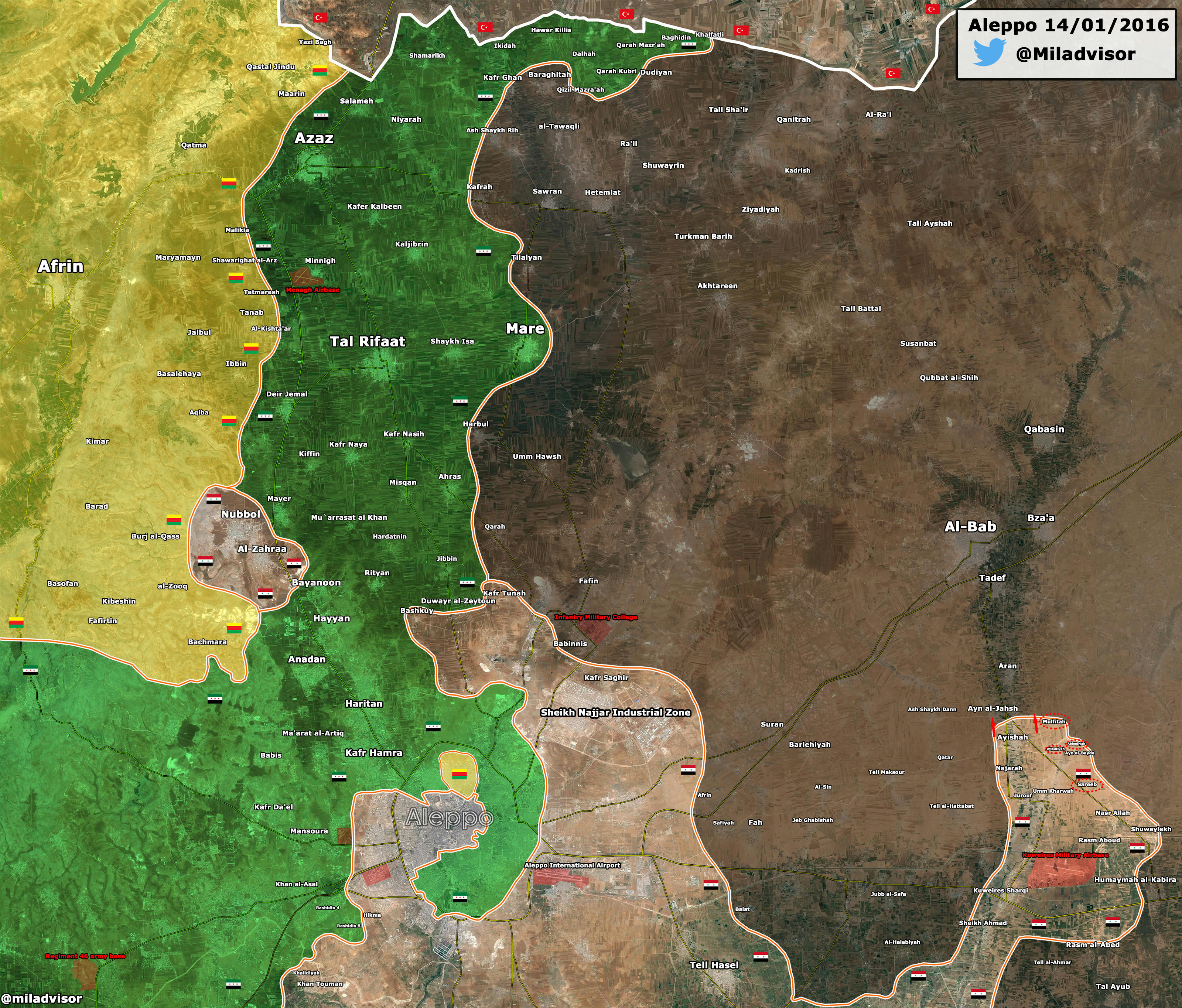
Isn't it risky to create such a protrusion, changing its shape in time EDIT wide only about two miles at its base!, into enemy territory?
If Daesh were to cut through that three kilometre neck it would cut off much larger forces than earlier in the Kuweiris air base. And the forces Daesh were to use would be destroyed by artillery and air bombardment as they would be well localized at or near that neck.
looking at this most recent map of Kuweiris Area, which seems to claim the Government Forces are pushing toward
I can only repeat my question from
Monday at 8:29 AM
That will concern the use of helicopters in that region as fixed wing aircraft have sufficient range and speed to work there while still based at Hmeymim.In addition to Hmeymim, Russia has used the Shairat airfield in Homs and al-Gayas airfield in Palmyra.
that's trueIf Daesh were to cut through that three kilometre neck it would cut off much larger forces than earlier in the Kuweiris air base.
that's cunningAnd the forces Daesh were to use would be destroyed by artillery and air bombardment as they would be well localized at or near that neck.
... the Government Forces
- even threaten ISIL with encirclement somewhere around Rayyan, in the middle above (Rayyan is ), as supplies aren't coming through "M4" anymore ...

I've been aware of the agreement for like two days now; I was curious how a professional translator would handle the first sentence of §12 (I would've just said "This is an interminate contract."), now I see:Today in WaPo:
The secret pact between Russia and Syria that gives Moscow carte blanche
...
This agreement is for an indefinite period.
my amateurish map from yesterday knocked out by the most recent "edmap"...
now I put this into one, recent map (Rayyan is the red spot below):

... now found this map:
the area controlled by Government Forces is marked off, plus the cross indicates their most recent gain (the village of Surayb); the yellow road goes to Raqqa, and Fah to the east is at the outskirts of Aleppo