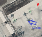
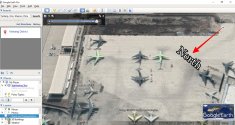
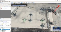
And also the image is reversed.As I explained, it is a low-resolution, black&white version of the original one and unfortunately I'm not allowed to post it.
You are using an out of date browser. It may not display this or other websites correctly.
You should upgrade or use an alternative browser.
You should upgrade or use an alternative browser.
KJ-600 carrierborne AEWC thread & possible KY-600 (?) COD aircraft
- Thread starter Blitzo
- Start date
And also the image is reversed.
really? I don‘t think so
Look on the maps how the white building is orientatedreally? I don‘t think so
lcloo
Major
It is the the angle of viewing. The black and white image posted by Deino is viewed from North to South direction, i.e. top of the picture is South and bottom is North.Look on the maps how the white building is orientated
Normal Google earth view is from South to North, i.e. top is North and South is bottom.
If you fly from South to North you get the "normal" image, and if you fly from North to South you get the "reversed" image. However, that is not a mirrored image if that is what you tried to express using the word "reversed".
Look, the building can be either on your port or starboard side, but if you switch only the flight direction between heading North or South, the façade of the building itself should not become reversed.
I assume that you are comparing with source like Google. I see facade in Google sourced photo, but no facade in the B&W photo (instead of reversed facade).Look, the building can be either on your port or starboard side, but if you switch only the flight direction between heading North or South, the façade of the building itself should not become reversed.
I think the B&W photo is not from Google. In Google sourced photo you see facade because the satellite taking the photo from an angel. The B&W photo is taken from a straight down view point.
Also, you can not match other features nearby if you reverse the photo such as the non tarmac surface to the south and the ground markings to the east.

Last edited:
Look, the building can be either on your port or starboard side, but if you switch only the flight direction between heading North or South, the façade of the building itself should not become reversed.
Lcloo's depiction of the orientation is correct.
The geometry of the building in the picture Deino posted is accurate, it is merely the orientation in which the picture which is taken that is different.
The image itself is not reversed.


