India incursion and Chinese standoff at Dolam, Bhutan

Status
Not open for further replies.

Hendrik_2000

Lieutenant General
@Jura From the link that you provide Seem like the Indian does not have justification to intervene in this dispute. And they make the same mistake like they did in 62 by interpreting the boundary unilaterally. some people just never learn the lesson of history and they will suffer the same like before. Deja Vu. They can crow all they want while they can but they will gnashing their teeth for the next 100 years
I rest my case I can't change your pov which is clearly taking Indian side but it doesn't really matter
Another thing in doklam there is treaty that delineate where the boundary is but in SCS there is no such thing so it is not the same argument. the Indian show they trespass

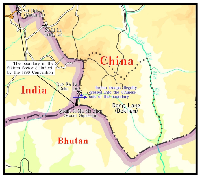
Is India, then, interpreting the 1890 Convention unilaterally? If so, then it is a dangerous game. Something similar happened when the MEA in 1959 “interpreted” the McMahon Line which, as per treaty, terminated on the Bhutan border at 27°44′30″ N. But when Indian patrols went there, they found that this was not the highest ridge of the watershed – that was at Thag La ridge, some 4 kms north of where McMahon had drawn the line on the map. The Indian side decided on its own that Thag La ridge was the boundary, and the Indian Army was asked to throw the Chinese off that ridge in an ill-considered operation that triggered the disastrous war of 1962.

In Part I of the Henderson Brooks report on page 54, section 33 noted “DHOLA post was established NORTH of the McMAHON Line as shown in maps prior to October/November 1962 edition. It is believed the old edition was given to the Chinese by our External Affairs Ministry to indicate the McMAHON Line. It is learnt we tried to clarify the error in our maps, but the Chinese did not accept our contention.”

(My comment) No justification and as usual they bring in SCS which is again false since UNLCOS has no jurisdiction over territory dispute. SCS is more like free for all where every one grab while they can. A road doesn't change status. If china bring missile it change the status. Just because you don't like your neighbor action doesn't give you the right to enter his property. It is called trespassing

While the Indians have been assertive in protecting interests that they consider vital to their security posture in the region, they remain cagey when it comes to the cartographic game. According to the Survey of India website, the map of Sikkim is
Please, Log in or Register to view URLs content!
.


There is a bottom line here, though not a very comfortable one. Which is that international agreements are merely worth the paper they are written on, unless there is some interest amongst the parties concerned to uphold them. The Chinese are upset at India’s attitude towards the 1890 Convention. But they should introspect about their own attitude to the UNCLOS arbitration award on the South China Sea in 2016 which they have spurned, just because it did not suit their interests.
 
Last edited:
Yesterday at 6:33 PM

here's the smaller Chinese claim:
136494625_15016882725911n.jpg


from inside of
Full text of facts and China's position concerning Indian border troops' crossing of China-India boundary
Xinhua| 2017-08-04 21:00:45
Please, Log in or Register to view URLs content!

...

The purple line does not reflect any "Chinese claim" but rather the line of actual control at the beginning of the current incident.
 
...
(My comment) No justification and as usual they bring in SCS which is again false since UNLCOS has no jurisdiction over territory dispute. SCS is more like free for all where every one grab while they can. A road doesn't change status. If china bring missile it change the status. Just because you don't like your neighbor action doesn't give you the right to enter his property. It is called trespassing

While the Indians have been assertive in protecting interests that they consider vital to their security posture in the region, they remain cagey when it comes to the cartographic game. According to the Survey of India website, the map of Sikkim is
Please, Log in or Register to view URLs content!
.


There is a bottom line here, though not a very comfortable one. Which is that international agreements are merely worth the paper they are written on, unless there is some interest amongst the parties concerned to uphold them. The Chinese are upset at India’s attitude towards the 1890 Convention. But they should introspect about their own attitude to the UNCLOS arbitration award on the South China Sea in 2016 which they have spurned, just because it did not suit their interests.

I disagree with the last paragraph of your post, the Doklam and SCS situations are incomparable.

Regarding Doklam both India and China are heirs to the parties to a mutually agreed to agreement which had been subsequently mutually agreed to again repeatedly directly by the current parties. India then without prior notice militarily violated and continues to violate an element of this agreement by crossing a local segment of the India-China border.

Regarding the arbitration on the SCS in 2016 only the Philippines participated in the arbitration done by a panel not officially connected to the UN or UNCLOS. China never agreed to the validity of the panel nor the arbitration as China had legitimately opted out of particular parts of UNCLOS which the Philippines/the panel tried to apply via the unilateral arbitration with regards to the SCS. China and all the other claimants are heirs to the parties (Taiwan as the ROC is actually a direct party) to historical agreements which gives China ownership of at least all the SCS islands though the other claimants have since repeatedly voiced disagreement with the historical agreements.

Two incomparable situations.
 
let the World see what the Chinese spinner
PanAsian
did:
54 minutes ago
Yesterday at 6:33 PM

here's the smaller Chinese claim:
136494625_15016882725911n.jpg


from inside of
Full text of facts and China's position concerning Indian border troops' crossing of China-India boundary
Xinhua| 2017-08-04 21:00:45
Please, Log in or Register to view URLs content!

...
The purple line does not reflect any "Chinese claim" but rather the line of actual control at the beginning of the current incident.
let's note where the Chinese spinner
PanAsian
put "..."
above, and now let's see the part replaced by "..." by the Chinese spinner
PanAsian
:
(an alternative border, dotted, on the Torsa River = let's say within the Doklam Plateau)

and here's the larger Chinese claim:
Yadong-county-claims-1.jpg

(found inside
Doklam, Gipmochi, Gyemochen: It’s Hard Making Cartographic Sense of a Geopolitical Quagmire
Please, Log in or Register to view URLs content!
20/07/2017
Please, Log in or Register to view URLs content!

)

(an alternative border around the basin of the Torsa River = beyond the Doklam Plateau)

the larger claim I noticed also

(courtesy of
tidalwave
who's taken his war efforts also down to the Andaman Sea: Today at 12:59 AM

LOL)

earlier today in (don't know how to link just that map):
vJ6j3.jpg


(an alternative border obviously to the east from the Torsa River = beyond the Doklam Plateau
)

I noticed this possibility (post in the closed thread)
#174 Jura, Jul 14, 2017
then unaware this claim has been known:


my homework ends

time will tell the rest

as you can see, I specifically referred to
dotted, on the Torsa River line
in the part replaced by "..." by the Chinese spinner
PanAsian
and NOWHERE in my post I mentioned any "The purple line" from the post of the Chinese spinner
PanAsian
#182
https://www.sinodefenceforum.com/members/panasian.382/
 

Hendrik_2000

Lieutenant General
I disagree with the last paragraph of your post, the Doklam and SCS situations are incomparable.

Regarding Doklam both India and China are heirs to the parties to a mutually agreed to agreement which had been subsequently mutually agreed to again repeatedly directly by the current parties. India then without prior notice militarily violated and continues to violate an element of this agreement by crossing a local segment of the India-China border.

Regarding the arbitration on the SCS in 2016 only the Philippines participated in the arbitration done by a panel not officially connected to the UN or UNCLOS. China never agreed to the validity of the panel nor the arbitration as China had legitimately opted out of particular parts of UNCLOS which the Philippines/the panel tried to apply via the unilateral arbitration with regards to the SCS. China and all the other claimants are heirs to the parties (Taiwan as the ROC is actually a direct party) to historical agreements which gives China ownership of at least all the SCS islands though the other claimants have since repeatedly voiced disagreement with the historical agreements.

Two incomparable situations.

(My comment) No justification and as usual they bring in SCS which is again false since UNLCOS has no jurisdiction over territory dispute. SCS is more like free for all where every one grab while they can. A road doesn't change status. If china bring missile it change the status. Just because you don't like your neighbor action doesn't give you the right to enter his property. It is called trespassing(My comment end)

That is what I am saying the rest is from the wire website (Indian site)

I did agree PRC and GOI as the heir of Qing and British empire should follow and respect the agreement because that is the custom of international treaty and agreement
And until it is replaced still valid which the Indian has conveniently ignored

And I agree LAC or line of actual control is the defacto border, It is not claim It is the border which our friend Jura try to implied disputed or not it is the border

Another thing in Doklam we have treaty so the border is fixed in SCS we don't so the border has yet to be delineated. And UNCLOS has no jurisdiction in border setting

So based on this there in no question the absurdity of the Indian claim that they have the right to trespass
 
Hendrik..., did you see
#182 PanAsian, Today at 6:15 PM
?
I try to be concise, I back up stuff with links, even try to accurately measure distances, look over old maps etc., and then some account simply puts into my mouth words I didn't say EDIT I was upset as it concerned factual information as expressed by the map

but that's fine, when I cool off, I'll briefly summarize the situation as I see it from the three sides: where the respective side is right, and where the respective side is wrong ... as viewed from the middle of Europe
 
Last edited:

Hendrik_2000

Lieutenant General
Hendrik..., did you see
#182 PanAsian, Today at 6:15 PM
?
I try to be concise, I back up stuff with links, even try to accurately measure distances, look over old maps etc., and then some account simply puts into my mouth words I didn't say EDIT I was upset as it concerned factual information as expressed by the map

but that's fine, when I cool off, I'll briefly summarize the situation as I see it from the three sides: where the respective side is right, and where the respective side is wrong ... as viewed from the middle of Europe

I don't understand what are you trying to say all I see is just couple of map
Put it in the simple language I don't put word in your mouth I assume you are saying it is territory claim by China
Well It is NOT it is the defacto boundary disputed or not
So it is Chinese territory and not claim as the indian said
easy,
PanAsian
put words into my mouth, not you

I'm working on my short-Doklam-story now LOL stay tuned
 
I don't understand what are you trying to say all I see is just couple of map
Put it in the simple language I don't put word in your mouth I assume you are saying it is territory claim by China
Well It is NOT it is the defacto boundary disputed or not
So it is Chinese territory and not claim as the indian said
LOL I quickly scrambled something you'll tore apart (and while tearing it apart, note all the points need to be considered together):
  • China is right in its claim, based on the Treaty of Calcutta, related to the current China-India border (I checked this myself in the closed thread: #174 Jura, Jul 14, 2017), BUT Bhutan wasn't a party to the Treaty of Calcutta
  • China has been negotiating about its border with Bhutan for decades, the Doklam Plateau has been among disputed areas Yesterday at 1:55 PM
  • China might claim much larger area to the east from the Doklam Plateau based on the basin of the Torsa River (I presume that's historic-Tibet territory, right?); I found myself a Chinese map presenting that larger area Today at 10:55 AM
  • I don't know what's the basis of the Bhutanese claim to the Doklam Plateu, BUT Bhutan has had a military installation in Batang La area, which is close to the CURRENT trijunction point Aug 6, 2017 it's particularly interesting in connection with point 2 above, isn't it?: why China didn't protest it for example last Summer??
  • Bhutan has numerous other border disputes with China, so if Bhutan backs off now in the Doklam Plateau, it'll be loosing the other areas, too
  • Bhutan wouldn't stand a chance against China, so it cooperates with India, but only this week the Foreing Ministers (China: Mrs. Sushma Swaraj; Bhutan: Mr. Damcho Dorji) met (and only in Kathmandu, Nepal)
  • If India leaves the Doklam Plateau now, China will be firmly established there (of course India doesn't consider the Doklam Plateau to be Chinese; India considers the Doklam Plateau to be Bhutanese)
I go to bed now
 
let the World see what the Chinese spinner
PanAsian
did:
54 minutes ago

let's note where the Chinese spinner
PanAsian
put "..."
above, and now let's see the part replaced by "..." by the Chinese spinner
PanAsian
:


as you can see, I specifically referred to
dotted, on the Torsa River line
in the part replaced by "..." by the Chinese spinner
PanAsian
and NOWHERE in my post I mentioned any "The purple line" from the post of the Chinese spinner
PanAsian
#182

LOL @Jura you can accuse me as whatever you want, there is way more spinning and blatant lying in pro-India/anti-China writeups regarding this incident than I can ever come up with. You highlight your own dubious credibility by being so vehemently defensive and accusatory in denying your own words which I quoted verbatim.

Your exact words were "here's the smaller Chinese claim:" with a colon directly before the map therefore clearly referring to the map. However nowhere in any of the source material where the map came from does anyone say any of the lines represent anyone's claims. Therefore it is your own opinion that the dotted line represents a "smaller Chinese claim".

After the map,

after another paragraph,

after another line break,

then you have in parentheses "(an alternative border, dotted, on the Torsa River = let's say within the Doklam Plateau)",

followed by "and here's the larger Chinese claim:" with a colon directly referring to another map.

If your post was written by someone else I might give them the benefit of the doubt that their post was merely unintentionally poorly organized but you have an established pattern of writing oddly worded and oddly organized posts, interspersing your opinions among facts in an obfuscating way to pass off your opinions as facts or as if they are from or supported by the referred sources when they are not.

Again I will call out your "smaller Chinese claim" statement as merely your opinion which was not stated nor supported by any of the sources you had.
 
Status
Not open for further replies.
Top