
You are using an out of date browser. It may not display this or other websites correctly.
You should upgrade or use an alternative browser.
You should upgrade or use an alternative browser.
Chinese UAV/UCAV development
- Thread starter AssassinsMace
- Start date
- Status
- Not open for further replies.


szbd
Junior Member
1st it's too early to say the final winner yet. I guess they will both keep upgrading.Why is the PLA using the Wing Loong series UAV's and not the CH series UAV's ?
Currently, I think wing loong is more powerful and flys higher. That's the reason.
antiterror13
Brigadier
Why is the PLA using the Wing Loong series UAV's and not the CH series UAV's ?
I think PLA will use both and keep the tight competition going .. good for everybody
Hendrik_2000
Lieutenant General
The solar drone "Phantom 5" of the Northwestern Polytechnic University, designed to provide WiFi to the ground, carried out a test flight of 16h


timepass
Brigadier
Source:
Details of Chinese sea-skimming lethal drone prototype emerge
Developed by defence prime China Aerospace Science and Technology Corporation's (CASC's) China Academy of Aerospace Aerodynamics (CAAA) subsidiary, the system has been given the product designation of CH-T1, although it is understood that the company prefers to identify it as the Ground Effect UAV (GEUAV) demonstrator.
The forward segment of the 5.8 m long GEUAV demonstrator is shaped like a conventional missile, with a cylindrical fuselage capped by an ogival nosecone where the radar seeker is located. Towards the rear is an unconventionally designed main body featuring two thick, long chord but short-span stubby wing structures running along the sides of its belly that combine to form a continuous wing-like undersurface. Two small outer wings can be found at the front of the main stub wings, along with upwards cranked V-tailfins at the rear that have an overall span of 3.8 m.
The air vehicle has a specified maximum take-off weight (MTOW) of 3,000 kg – although the prototype weighed significantly less during trials as it only carried partial payloads and fuel loads – and achieves take-off via rocket assisted catapult launch. It can be powered by either a turbojet or turbofan engine, which enables it to travel at a maximum speed of Mach 0.65 (802 km/h) while cruising at terrain hugging altitudes of 1–6 m. The engine draws its air from an intake located on top of its main body to avoid ingesting sea spray during low level flight overwater.
That "Erknatoplan" design should be more used, because it look it only have advantages.
Perhaps the problems in the flight envelope are greater than we think.
Hendrik_2000
Lieutenant General
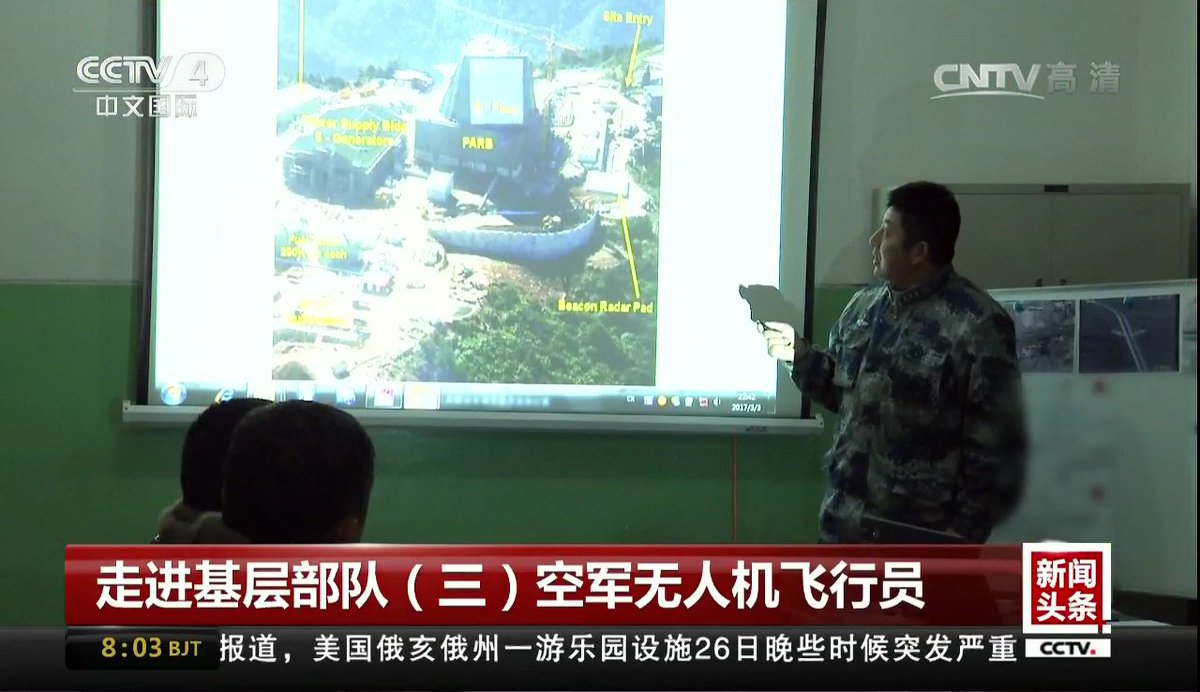
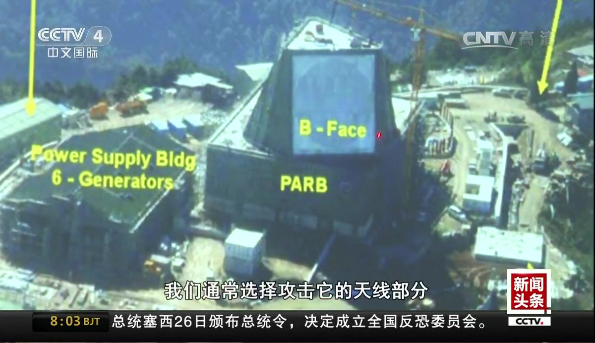
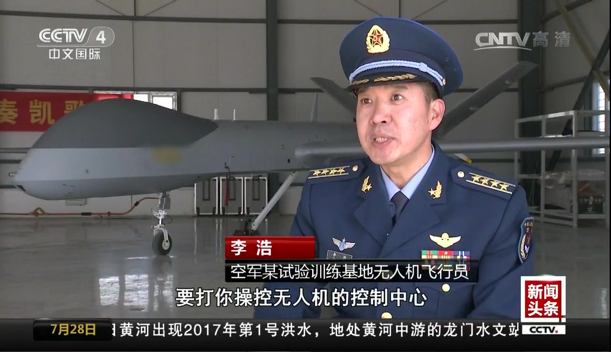
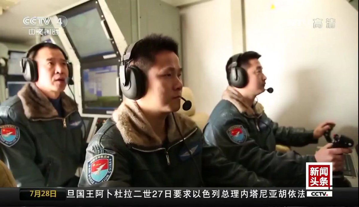
Chinese military drone pilots learn to hit foreign radar stations.
Now who could the foreign radar be ? Any wager?
Now who could the foreign radar be ? Any wager?
Solar power drones can have endurance for month or years, and it would even be cheaper than satellite to operate.
China to fly space-based, solar-powered telecom drones
China plans to build a space-based, solar-powered drone (UAV) telecommunications network capable of providing week-long emergency assistance on the ground.
A research institute affiliated with China Aerospace Science & Industry Corp (CASIC) is developing the space-based telecommunications project called "Feiyun," which means "flying cloud," Science and Technology Daily reported Tuesday, saying that the network will be based in near space.
The network can provide week-long emergency communications access and is expected to go on trial later this year.
The technology is crucial for rescue work during natural calamities, Cao Limin, an expert at the Nanjing University of Aeronautics and Astronautics, told the Global Times on Tuesday.
Cao said that emergency communication vehicles are currently used in such situations, which are rendered useless when a calamity prevents access to the site. "A UAV network is immune from such conditions," Cao said.
Ma Hongzhong, head of the institute was quoted by Science and Technology Daily as saying that UAVs can fly as high as 20 kilometers in near space for days - somewhat like a telecommunications satellite - and can also carry out remote sensing and telecommunications relay signals.
Drones operating in near space can free themselves from other disturbances because it is too high for other objects to reach, and the drones can absorb more solar energy closer to the sun, Wang Peiji, an expert at Harbin Institute of Technology's School of Aeronautics, told the Global Times on Tuesday.
The near space area, which is 20 to 100 kilometers above sea level, contains thin air which would inhibit the functioning of fuel-powered aircraft engines, read the report.
Experts also warned that the severe environment in near space poses as a challenge to the UAV.
"If these problems are solved, the UAV in near space would be of great value in many areas," Wang said.
Ma said that compared with low-orbit satellites, the high-flying drones are easy to maintain and control, and can better provide high-resolution data than satellites in high orbit.
The UAVs can be used to warn of natural disasters, sea management and counter-terrorism, according to a press release sent to the Global Times by the institute on Tuesday.
They are also expected to be used as "airborne Wi-Fi hubs" to provide convenient mobile telecommunications and Internet access for remote areas and islands, which would save on construction and maintenance costs of traditional infrastructure, the Xinhua News Agency reported in June.
Wang noted that the UAV also has military uses. "Its remote sensing technology can help the military get accurate information with higher definition." In June, China's first solar-powered UAV, the Caihong (rainbow), completed its first successful near-space test flight at an altitude of more than 20 kilometers.
The much-heralded private industry coming through?
China’s CASC plans app-based control system for Cai Hong UAVs
Kelvin Wong - IHS Jane's International Defence Review
03 August 2017

CASC engineers ready a pair of CH-4 strike-capable reconnaissance UAVs for a flight test in northwestern China. The company is developing an app-based interface to simplify higher order UAV operations. Source: IHS Markit/Kelvin Wong
Engineers at the Beijing-based China Academy of Aerospace Aerodynamics (CAAA), the unmanned aerial vehicle (UAV) platform, systems, and technology business unit of defence prime China Aerospace Science and Technology Corporation (CASC), are developing a new app-based UAV management system specifically designed to reduce the complexities of operating larger, multirole air vehicles in the medium-altitude long-endurance (MALE) class.
Jane’s sources revealed that such an effort had been under way since 2014 and the company aims to have early software builds ready for field trials “in the near future”. It is expected that the yet-to-be-named app-based system will be made available as an option for the company’s flagship products such as the Cai Hong 4 (Rainbow 4, or CH-4) – which is already in service a number of countries in Central Asia and the Middle East – and the recently market-ready CH-5 strike-capable reconnaissance MALE UAVs when fully developed.
A company official briefed Jane’s that the proposed management system takes the form of open architecture software that exploits the high level of automation that is already inherent in the company’s UAV platforms – which are already capable of automatic take-off and landing and autonomous navigation – to enable an operator to assign tasks to one or multiple platforms using easily identifiable app icons.
“Our app-based approach is designed to increase the effectiveness of UAV missions by raising operator focus from the level of tactical operation to that of supervision,” the official explained. “By automating most, if not all tactical functions, we are also aiming to ease the cognitive burden on operators, enabling them to supervise and command multiple concurrent UAV missions without losing effectiveness.”
China’s CASC plans app-based control system for Cai Hong UAVs
Kelvin Wong - IHS Jane's International Defence Review
03 August 2017
CASC engineers ready a pair of CH-4 strike-capable reconnaissance UAVs for a flight test in northwestern China. The company is developing an app-based interface to simplify higher order UAV operations. Source: IHS Markit/Kelvin Wong
Engineers at the Beijing-based China Academy of Aerospace Aerodynamics (CAAA), the unmanned aerial vehicle (UAV) platform, systems, and technology business unit of defence prime China Aerospace Science and Technology Corporation (CASC), are developing a new app-based UAV management system specifically designed to reduce the complexities of operating larger, multirole air vehicles in the medium-altitude long-endurance (MALE) class.
Jane’s sources revealed that such an effort had been under way since 2014 and the company aims to have early software builds ready for field trials “in the near future”. It is expected that the yet-to-be-named app-based system will be made available as an option for the company’s flagship products such as the Cai Hong 4 (Rainbow 4, or CH-4) – which is already in service a number of countries in Central Asia and the Middle East – and the recently market-ready CH-5 strike-capable reconnaissance MALE UAVs when fully developed.
A company official briefed Jane’s that the proposed management system takes the form of open architecture software that exploits the high level of automation that is already inherent in the company’s UAV platforms – which are already capable of automatic take-off and landing and autonomous navigation – to enable an operator to assign tasks to one or multiple platforms using easily identifiable app icons.
“Our app-based approach is designed to increase the effectiveness of UAV missions by raising operator focus from the level of tactical operation to that of supervision,” the official explained. “By automating most, if not all tactical functions, we are also aiming to ease the cognitive burden on operators, enabling them to supervise and command multiple concurrent UAV missions without losing effectiveness.”
- Status
- Not open for further replies.